February 2017 Archives
GNSS & Educational Equations: A Grid-to-Ground Project
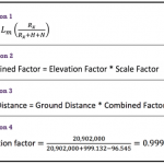
When planning GNSS control surveys on highway projects, it is important to understand the limitations of GNSS. Most highway projects are long, and linear distances that are wide open horizontally and vertically and are ideal for GNSS surveying. However, in rural and city areas, tree canopies and high-rise buildings will obstruct the GNSS signals, so […]
Industry Innovation: Are You Ready to be Relevant?

Slay the beast named Apathy with progress. This is a dire warning. There is a beast that threatens to destroy the land surveying profession. It is a danger to you, your company, your coworkers, and your employees. It sucks the life from all it contacts. Its victims are left empty, with a sense of impending […]
Orbit GT & Integration in the Mapping Business

A new software integration tool attacks what I call “workplace technology interplay denial.” Above: At BPG Designs, plenty of screens are filled with integration software. Through our smartphones, we are now integrated with all the people we know (and don’t know); we have integrated our work spaces with our home lives; and we can even […]
21st Century Survey: Milestone Surveys’ Innovation Makes a Global Workstation
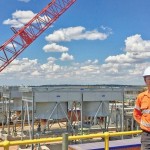
Milestone Surveys is a digital child of the current century: working in the cloud and across the globe while maintaining fundamental surveying practices. Extinction is certain for geospatial companies that plan to make a profit tomorrow the way they did yesterday. In order to survive and thrive in the 21st century, surveying businesses must blend […]
Championing GNSS for Surveyors
Lonnie Sears co-founded and runs Champion with dedication to training, quality, and cost. Editor’s note: The theme of this month’s issue is surveying innovation, so we felt it fitting to present the story of Champion Instruments. This firm was started by an American surveyor who responded to what surveyors were asking for and who has […]
Surveying on Mars
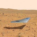
The subject of Mars exploration and colonization is suddenly red hot. What role might there be for surveyors in this, the grandest of human endeavors? Above: The Prandtl-m is a conceptual fixed-wing drone for Mars mapping that will be tested this year from a balloon drop over Earth at an altitude of 35,000m to simulate Mars’ […]