March 2017 Archives
Project Management, Collaboration, the Cloud, and Robots!
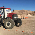
Above: An autonomous farm tractor drives on a demonstration course at Trimble Dimensions. In addition to following predefined paths and instructions, the on-board tractor systems can sense and react to obstacles. Trimble launches a new solution for construction project management– and takes a futuristic leap into autonomous construction vehicles. by Matteo Luccio and John Stenmark Editor’s […]
How to Prepare for Oops in UAV Management
Insurance Coverage for UAVs in 2017 It’s inevitable. If you own a UAV, chances are that you will experience a (hopefully only minor, but potentially major) type of accident-related claim involving that UAV due to human or technical error or to weather. Having been a broker in the insurance industry for more than 30 years, […]
GPR and Surveying at Hilti
High-tech tools for construction surveying can also be used by land surveyors and new surveyors. By Jeff Salmon Construction, both residential and commercial, is the second-largest industry in the world–surpassed only by agriculture. From site plans and stakeouts to as-built surveys and, now, BIM, construction has and will continue to provide a major market for […]
GNSS in Construction
Above: Using GNSS networks in construction saves time and reduces the potential for errors. Credit: Leica Geosystems. Forward-thinking contractors are signing up for network subscriptions in record numbers as the benefits become more widely understood. By David Rowlett John Hugerich still remembers using a base station and setting up a local network for every stockpile […]
GNSS Mission: Accomplished

Above: Interviewed during our visit to Hemisphere GNSS’s headquarters, left to right: Jos Briceo, senior VP of business development; Rodrigo Leandro, senior director of engineering, and Randy Noland, VP, global sales and marketing. How a revitalized Hemisphere GNSS hit “reboot” and developed a new family of RTK and L-band positioning solutions for surveying. By Matteo […]
Converging Worlds Data, Imagery, and the Pipes Below
Above: Hydromax USA data (sewer and gas) is combined with Nearmap imagery and Esri software, improving analysis and resource deployment. A data-collection company transforms its services with clear, streaming imagery. By Nicholas Duggan, FRGS, Cgeog (GIS) When you get new aerial imagery, the first thing you do is look up your house. (It’s okay, we […]