xyHt in print April 2015 Archives
25 Tips for BIM

Expert Recommendations for Better As-built BIMs Creating as-built building information models (BIMs) has been greatly facilitated by the introduction of 3D laser scanners and modeling software, but the process still has its challenges. Four experts were asked to put their decades of combined scanning and modeling experience into this list of the best tips, tactics, […]
The Right Right

Igor Kidinsky thought about another career for a fleeting moment. His cold fingers struggled to fine-tune the total station. As an Afghanistan war veteran, he sometimes dreamt of spending his life closer to a beach rather than continue freezing in the mountains. He would leave his crew-name of Eager (the Kid) behind and put his […]
Tracking Aircraft in Flight

From surveillance methods using ground-based radar to space-based systems, it’s more complex to track aircraft than you might think. The disappearance of Malaysia Airlines Flight 370 on March 8, 2014, with 239 people on board, was both tragic and stunning. The loss of a modern commercial aircraft operating in government-controlled airspace, which remains unexplained, represents […]
RFID
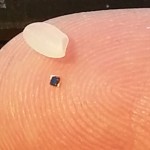
Above: RFID tags take many forms. The inside of a tag shown above—designed to attach to metal infrastructure in harsh environments, such as water pipes and valves—has a thin copper “bow-tie” antenna with a minuscule chip in the middle. It’s shown contrasted with a grain of rice. An electronic handshake has brought together the worlds […]
Maptime

A new source of support for mapmakers is spreading internationally. With so many sectors and niches, the spatial/IT industry was falling into silos. Then, seemingly from out of nowhere groups started appearing, first in the United States and then in Europe, under the label “Maptime,” in a similar fashion to the hackathons a decade ago. […]
Mapping Peripheral

A review of Trimble’s R1, a GNSS Bluetooth peripheral for mobile devices, with multiple options for correction sources. The idea of a GNSS “puck” has broad appeal: a peripheral GNSS receiver to precision-enable mobile devices such as smart phones, tablets, and a variety of purpose-built field-data-collection devices. There is a lot of functional territory between […]