xyHt in print May 2015 Archives
Mapping the Appalachian Trail
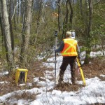
How the AT was created and surveyed, from Avery’s wheel to GPS The Appalachian Trail (AT) is very old, very long, and iconic. Completed in 1937, it stretches 2,189 miles through 14 states, 88 counties, 168 townships, eight national forests, six national parks, two national wildlife refuges, and more than 65 state game lands, wildlife […]
EagleView
The practical side of on-demand aerial image analytics, with an interview of CEO and president Chris Barrow. A contractor showed up at my house to give an estimate for a long overdue roof replacement. He hadn’t pulled out a ladder, so I asked if he needed mine. His response was, “Since we started using EagleView, […]
Robots to the Rescue

Above: A representative from The German Federal Agency for Technical Relief operates a UAV. The potential for unmanned vehicles conducting search and rescue is proven in Southeastern Europe. Editor’s note: In our January issue we highlighted ways unmanned aerial vehicles are being used worldwide (UAVs for the Whole World), including for conservation, at high altitudes, and […]
Proving Ancient Measurement Methods

Surveying students calculate the Earth’s circumference by following Eratosthene’s method, with help from modern sources. As part of the Geodetic and Control Surveys class at Dunwoody College of Technology in Minneapolis, Minnesota, we have been studying the history of Eratosthenes and how he calculated the circumference of the Earth. As a class we decided to […]
The Beaten Path
Art of Retracement With a set of eyes that had focused on survey lines through several eras, the Old Man (Glenny Dale, also known as Glutton), took one look at the cluster of three monuments along a right-of-way fence line. The site of three pins at a point where there could be only one legal […]
A Global Geodetic Roadmap

Above: Ambassador Peter Thomson, Fiji’s permanent representative to the United Nations, presents to the General Assembly the resolution titled, “A global geodetic reference frame for sustainable development.” The United Nations takes up the call to develop a global geodetic reference frame for sustainable international relief and development. Geospatial technologies that have quickly become commonplace and essential in industrialized […]