xyHt in print November 2014 Archives
Artful GNSS

Things in the nation’s capital can happen quickly, but only when the parties involved agree to work closely together towards a common goal. Internationally renowned artist Jorge Rodriquez-Gerada was given six months to develop a plan and complete a six-acre painting using sand and topsoil. His canvas would be an incredibly high-profile piece of National […]
Pix4D Mapper
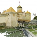
Imagine walking up to an object with practically any camera and taking photos of it at different angles. Now imagine uploading those images onto a computer and being able to create a survey-accurate point cloud. Sounds impossible, huh? Too good to be true? That’s what I thought when I first heard of Pix4D. When I […]
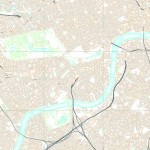
Open Source in the UK
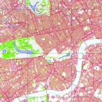
Contrary to popular belief, it was neither the UK government nor Britain’s national mapping agency, Ordnance Survey, who started the UK open-source movement. Although open source was present and used in the UK before 2006, it was The Guardian newspaper that started a campaign called “Free Our Data,” which called for the raw data collected […]
Open Source
The door to open source geospatial software has been unlocked. It’s time to take a peek inside. The open source geospatial movement is not purely about “free” (as in no cost). There truly are other aspects of “free,” as in “free to develop without constraints,” and free access to public geodata without necessarily having […]
All Over the Map
The regulations and uses of UAVs for mapping in Latin America are as diverse as those cultures, but their drivers are much the same as we see here in the United States. Using manned airplanes for aerial photography and photogrammetry is an especially expensive proposition for countries south of the Rio Grande. The reasons are […]
Crafting The Future via Geodesign
Geodesign is on the move. While the term may be new to some, it is an old concept getting new life via modern technology: how the science of geography should inform our methods of design. In that sense, geodesign is an applied science, and we humans have been doing it naturally since the dawn of […]