An Interview with the hand-drawn map creator, Kevin Sheehan
There isn’t much you can’t do with digital media nowadays, from effective maps using shadows and drop effects to using graphic-design packages to make the map “pop”—except for one thing—capturing that hand-drawn style, the way that the pen line moves in and out from the pressure of the hand or the slightly uneven but perfectly drawn contours.
Yes, hand-drawn maps are an art that combines the love of freehand drawing with the accuracy and detail of an engineer. When I stumbled across Kevin, who was talking about some of the hand drawn maps he has made, I couldn’t resist contacting him.

ND: How did you start drawing maps?
KS: I’ve always loved maps, even from quite a young age. I started drawing maps (by hand) as a child, and in high school made several hand-drawn fantasy Tolkien-esque maps in art classes, experimenting with different drawing, printing, and painting techniques.
When I came to Durham in 2003 for university and drew a couple ink-on-paper maps of Durham to give as Christmas gifts to my parents. In 2011, at a dinner party, the new head of the Durham World Heritage Site asked me about drawing maps, and following from that, I was hired by Durham University Retail to draw the Durham University and Pubs of Durham maps for them to sell prints of at the new World Heritage Visitor Centre.
At the time, I was also studying a PhD in the history of cartography, looking at manuscript nautical charts between 1200 and 1600, known as portolan charts. In 2012, as a part of the thesis, I drew a portolan chart on parchment using medieval techniques that would have been used at the time in order to figure out a bit more about how maps were drawn and copied several centuries ago.
In 2014, after I finished my PhD, I began my business – Manuscript Maps – and drew some of the other maps that are currently offered on my website (plus a few other private commissions), including the Whisky Map (my best seller), the Gin Map, and the Shipping Forecast & Lindisfarne Maps, which were both commissions of which I’ve retained the copyrights.

ND: Do you have a geographic or GIS background?
KS: I don’t have any formal geography training; any that I did pick up was during my BA in archaeology, my MA in Medieval history, and PhD in medieval and early-modern cartography (but very much from a historical perspective, not geographical). I might struggle more to draw maps on a computer than how I do them by hand, though I AM self-trained and quite adept at using Adobe Photoshop, Illustrator and InDesign.
ND: What inspirations do you have?
My earliest cartographic inspirations were probably the maps in Tolkien’s The Hobbit and The Lord of the Rings (the books, rather than the films). In high school, as mentioned earlier, I drew some maps as part of my International Baccalaureate Art Module, experimenting with different mapping styles. During my MA programme, I took a course in History of Cartography with Paul Harvey, who is the world’s leading scholar on the Hereford Mappamundi. While I have always had a love of maps and had drawn maps before, it was doing that course that inspired me to work much more significantly on maps, and I really became inspired by old maps from the Middle Ages to about 1800. I love how decorative and artistic maps were back then, in comparison to now where so many maps are purely functional and quite boring.

ND: There is so much clarity and detail. What is the process for making one of your maps?
KS: I start with a few sketches, just on A4 paper, working out a general plan and layout of what the map will look like. I then use a thick hot-pressed watercolour paper on which to draw the actual map. Everything then gets planned in pencil. Once the pencil is done and I’m happy with the look, I go over in pen; I use waterproof ink and dip-pens with different calligraphic nibs.
I begin with the text, which has to be done first, so as to leave the white space around it. Then various elements like rivers, coastline, buildings, etc., and decorations, and finally shading, like the lines in the sea of the Whisky and Gin Maps.
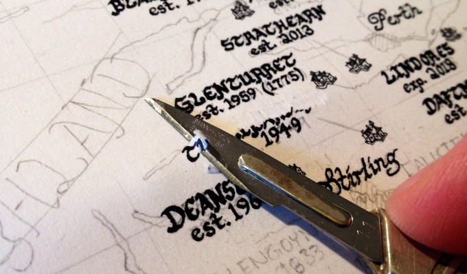
If I make a mistake, I let the ink dry, then use a scalpel blade to remove the thinnest layer of paper and the ink mistake, rub over the area with a smoothing tool, then redo it. There are always a few mistakes, but they wouldn’t be noticed on the prints.
Once the drawing is done, I use an eraser to remove any pencil marks and then scan the map to a 600dpi tiff file. I then do a little adjustment in Photoshop (to make sure the black prints as pure black and not grey), and then the file is sent off to be printed, using a print company in Newcastle.

ND: Your maps are so beautifully crafted, how long does each one take?
KS: The time really depends on the size and the complexity of the map. The Whisky and Gin Maps took over 120 hours each to draw, plus a lot of time doing research and contacting distilleries for permission to draw their logos on the maps. The Shipping Forecast Map only took about 30 hours to draw, but it’s much more simple. Decorations and shading take the most time – the sea on the Whisky and Gin Maps are shaded with individual lines, and there are probably a few thousand of them on each map, each line drawn one at a time.

ND: It appears that you have a gift for web design too; your site is as beautiful as your maps! What plans do you have for the future?
KS: Thanks! This year I’ve got a few map commissions, including one of the Yorkshire Ridings which I hope to keep the copyright to sell prints of. I’m also planning on drawing a Cheese Map of the UK, a Rum Map of the Caribbean, a Map of London Theatres, an Irish Whiskey Map, a City of York Map, and two planisphere-style world maps: one of Teas and one of Coffees.
Kevin Sheehan is the owner of Manuscript Maps, one of a handful of ol- fashioned hand-drawn cartographers/artists. His website is well worth a look as it is as beautiful as the maps above and can be found here. You can also contact Kevin through the website for more information or personal commissions.