State Plane Coordinates in Legal Descriptions
The time is now to have State Plane Coordinates (SPC) attached to key monuments that should be part of just about any legal description, in the proper context.* This has been discussed since the early 1980s and has been accomplished only on a piecemeal basis. With coordinate inclusion, a powerful quality control ability is shared with many subsequent users of the legal description. The coordinates also provide a direct link between the written legal description and its map representation.
GIS and surveyor interests should work together state by state and nationally to review the need for any enabling legislation to allow local entities to require SPCs for inclusion in nearly all legal descriptions. The coordinates become a visible and tangible “double check” of most of the components in the legal description.
*Experts do understand that, authoritatively, coordinates are low in priority. Coordinates have standing after intent, senior deed references, monument descriptions, distances, and bearings—in that order. However, they are the easiest data to extract from the legal to enter into a GIS or other software.
Better Legal Descriptions
More care needs to be given to the preparation of legal descriptions of all kinds and types. Because surveyors and GISers often review legal descriptions of many different types they are in a good position to identify many of the problems. Legals often do not “close” or accurately bound the area in question. Orientation is often a problem—“is it true north, magnetic north, astronomic north, geodetic north, or an assumed north?” Often errors are propagated from one instrument (or legal) to another simply by copying the legal description. With the misunderstanding of intent and certain rights comes the possibility for errors to creep into mapping via questionable legal descriptions.
The survey and GIS communities need to work together to better educate the title community about the importance of proper legal descriptions. (For more on this topic, see our article in Professional Surveyor, June 2014.)
Geodetic Control
GIS needs a more robust geodetic control framework. Too often geodetic control is implied from the last aerial photography flown or from the photography used for the original GIS base map automation. Often, as well, the geodetic control for the initial imagery was not included in the original GIS data model, nor was independent geodetic control developed for the GIS.
This is even more important as the GIS framework becomes the integration model for tying together more data from government and the private sector. In fact, the geodetic control layers in the GIS should become a larger repository of all things geodetic. Given an enterprise GIS implementation, these layers and themes may well be the responsibility of the city or county surveyor. Imagine much more robust geodetic control layers or themes in the GIS.
Better Monumentation
Surveyors have done a vastly improved job of identifying monuments in the field over the years. The tough job is cross-referencing the monuments in the field with the proper references and calls in the legal descriptions. It is very critical that monuments be better identified as to surveyor, date, and legal description relationship.
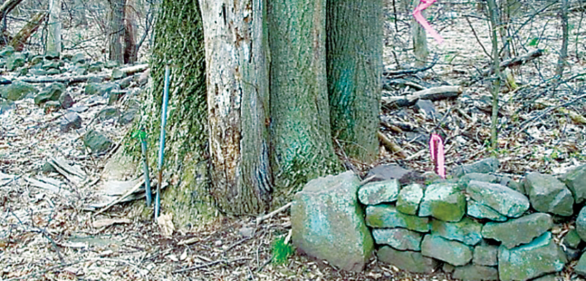
The image (below) demonstrates the difficulty of understanding deed calls, applying measurements, and using monuments across many years. Surveyors call this the pin cushion effect. They know that the definition of a monument may also include the stones, stone fences, and trees. Without serious in-depth deed research and analysis and understanding of case law (determined by the courts), it can be difficult to determine the actual property corner.
Each property owner who paid to have “their” corner set probably believes theirs is the correct corner. GIS folks want to have one location or node; they might be inclined to look at the center of the clump of trees as the common parcel corner. We have to respect the fact that measurements can change. The measurements in the first survey in this area could have been performed by pacing; subsequent measurements may have been made with chains, steel tapes, stadia, lasers, and GPS tools. It becomes easy to see how the pin cushion is created when there are so many variables, inconsistencies, and ambiguities in deeds, changes in use of land, changes of ownership and intent, and varying methods of measurement.
x-y-z(H) Data and Datums
The U.S. Federal Communications Commission recently promulgated new rules to ensure that wireless caller locations can be specified to the proper building and floor in multi-story buildings in the next five years. As GIS becomes more descriptive at representing the as-built environment, where will all these “z” (or H) coordinates come from? We are going to need GIS and survey interests to work together to have a more survey-grade designation of all z coordinates. For some sites that have multiple entrances at multiple elevations we will need to rethink our z and other closely related “cultural” datums. Is the ground floor for elevator #1 the same as elevator #8?
Surveyors can help us sort through these issues. Some GIS data models are still back on NAD27 horizontal and NGVD29 vertical datums. Time stamping of our data will become more important; we will be looking for more metadata about our positions.
With the evolution of new datums, adjustments, gravity, and ellipsoid models it is important the GIS interests begin a real discussion with the survey community about where are we going together.
3D/Subparcels
We must stop being just 2D flat mappers and see GIS in its full fidelity. This fidelity must include individual apartments, suites, and occupancies, mineral rights, and easements. As individual parking spaces are now being bought and sold in Boston and New York City we must be ready to track all those entities as well. Most GIS people are still thinking “building points,” and they are not going to cut it! We must now also consider all the subparcel components.
The GIS and display technologies are now able to do much of the above visualization. The ability to merge images with our 3D GIS frameworks is now possible. The ability to “grab” suite # 3219, examine it, walk through it, and give us size (square ft/meters) and volumetric data, along with view potential is needed now for condominium valuation. Our GIS frameworks are not keeping pace with the real demand if we are still talking building or address points!
GPS/GNSS—for Surveyors Only? Or Is GIS a Tool, Too?
In the past, when surveyors saw GIS staff using GPS gear in the field, the flags would go up. GIS staff would respond, “We’re just trying to find things.” If GIS staff are trained by a knowledgeable surveyor and post-process their data against CORS (cooperative Continuously Operating Reference System), then the ability to “find” things, accurately, and not be a licensed surveyor, is possible with GPS/GNSS. More discussion is required as real-time positioning networks become prevalent. With GPS-enhanced cell phones, tablets, and pads a much bigger audience is now collecting GPS points and other critical, attribute information. Clearly, the question is: Will we have the GIS frameworks in place to handle this huge influx of geo-locational data in the future?
Our GIS frameworks will be built and maintained by various disciplines using a larger body of knowledge that includes both GIS and surveying! Economist Joseph Schumpeter had it right: when disciplines or ideas collide new and better ideas arise. These seven issues/opportunities will provide a move-forward perspective for GIS and surveyors as they work more closely together. We’ll address each of these topics in future print issues and online.