
Before 3D GIS, we were able to measure miles below the sea and miles beyond our own atmosphere to a great level of accuracy, so how did we do it?
There are a few methods for working between vertical coordinate systems, but the one I want to discuss is possibly the simplest, not always the MOST accurate but good enough for many of today’s simple 3D applications. It is one I was taught by a master mariner and offshore surveyor that is still used widely in the offshore industry today, commonly called measurement by tidal survey, opposed to geodetic datum used onshore.
The method works by calculating the differences between Mean Sea Level (MSL), tide gauge, or local vertical vertical coordinate system, as they are all related and constantly measured for both consistency and accuracy.
What Is a Tide Gauge?
If you have ever been to the beach and seen a big ruler attached to the wall, this is a rudimentary tidal gauge.

Rudimentary tidal gauge at the beach
Tidal gauges are used to measure the tides (obvs) and MSL. By observing the sea over long periods of time we can not only get an accurate measure of datum but also make predictions.
How Does a Tide Gauge Dictate Datum?
For decades, the only way to express topographic or bathymetric elevation was to relate it to the seas’ level. Geodesists believed that the sea was in balance with the Earth’s gravity. MSL is the mathematical mean of hourly water elevations observed over a described 19-year cycle; by measuring over this specific period, the highs and lows caused by gravitational effects can be averaged.
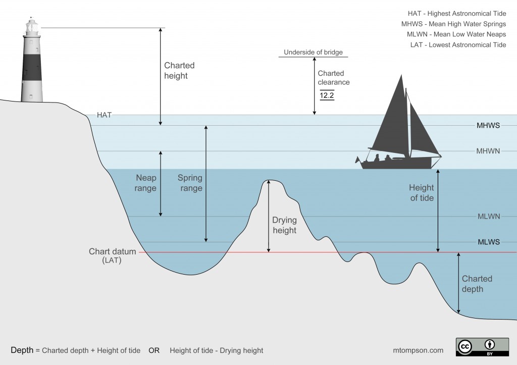
Tidal heights and chart datum
If you are reading this, I am assuming you already know a little about datum and geoids, therefore I’ll just say that this sea level creates an equipotential surface (geoid) which is commonly used to define WGS84.
Local coordinate systems are commonly based on local tide gauges. Take for example the Ordnance Surveys’ Newlyn vertical datum. This is based on tide gauge measurements taken at the [Newlyn] observation centre in Cornwall.

A seemingly ordinary lighthouse, until you spot the GPS antenna. This is the OS Newlyn tidal observatory.
To keep this more accurate for mariners, there are many tide gauges located all around the UK, as this makes for a more accurate vertical reference. You may have heard of the term “Chart Datum.” This refers to the datum (recorded at the Lowest Astronomical Tide [LAT] – see image above) for the tide gauge which is referenced in the navigational chart.
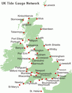
Tidal Gauges for the UK, courtesy of BODC http://www.ntslf.org
Working between Datum
With tide gauges all around the world, there is also a plethora of data. Places like NOAA & NOC provide accurate calculations to work between these gauges.
So, if you have your data in Newlyn, you can quite easily recalculate all your data to another datum. This can be done for most, if not all, tidal datum and then converted to geodetic datum.
PSMSL is a great website for working out the differences; see this screenshot of the Liverpool data:
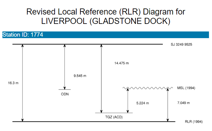
Screenshot of Liverpool references from the PSMSL website
NOTE
Please keep in mind that this method of working with vertical data will work as a BASIC method of working between vertical coordinate systems. Keep in mind what accuracy your data currently has and also the accuracy of the conversion method (note in the above image that you may need to convert between 1994 MSL and 2016 MSL).