The 2015 Esri Developer Summit (colloquially referred to as the “DevSummit”) was held in Palm Springs, CA, March 10-13. Two thousand+ programmers and technologists participated, seeing the latest developments for building applications in ArcGIS web, desktop and native coding environments.
I particularly enjoy the DevSummit events, since they are entirely geekfest in nature, as opposed to the Esri User Conference lovefests that are taking on more and more of a cult worship air. Living up to a stereotype of political incorrectness, geeks tend to ask more pointed questions about Esri’s ArcGIS core technology, which has been increasingly showing its age. But (and this is a huge “but”) there are breakaway pockets of technical modernity that are being pursued by the giant in the GIS software industry.
Here are my picks for the most relevant trends and product developments that were shown at DevSummit 2015:
- AppStudio for ArcGIS: a QML code compiler that develops native apps for Mac, iOS, Android, Windows and Linux. AppStudio requires an ArcGIS Online subscription (although developing using AppStudio supposedly doesn’t use any credits), ArcGIS Runtime licensing at an appropriate level, and Qt Creator ($174/month (!)). Cool and all that, but expensive unless you’re a dedicated commercial developer. The beta software is available at the AppStudio link, and is certainly worth tinkering with.

AppStudio
- Javascript API 3.13: The latest release of the ArcGIS JavaScript API was released at the DevSummit, and included these significant new features:
- Vector map tiles: Although raster map tiles have been the go-to technology for rapidly displaying maps, vector tiles are relatively new (at least in the ArcGIS world) in that a static grid of cached vectors is used for mapping display. Queries on features don’t have to be relayed back to the server, and thus overall display and map interaction is sped up greatly.
- Smart Mapping: basically automatic symbolization developed from a scan of a feature’s attribute fields. Smart Mapping is just available with ArcGIS Online subscriptions. A really good video on Smart Mapping is on this YouTube video.
- Geometry Engine: still in beta, Geometry Engine works on locally-cached features, saving any round trips to ArcGIS Server to fetch necessary vector features. The demo on this was impressive, showing a map frame with a roving buffer selector polygon and an associated tabular table highlighting the selected features in real time.
- A new Search Widget that supersedes the now-deprecated Geocode Widget. The Search Widget operates much like a Chrome omnibox, handling not just web URLs but also searching using the input string to display context-relevant websites. You do have to provide the Search Widget with a defined range for searching, either a list or a single source.
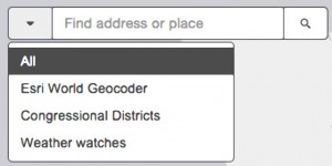
SearchBox
- AngularJS 2: the probable new direction for Esri to replace Dojo as its JavaScript API backend framework. This was the most interesting development for me, as (1) I’m an Angular geek, and (2) Angular2 is being developed in partnership with Microsoft. This was the session that re-instilled in me a new hope for Esri’s relevance in the web mapping world.
- ArcGIS Pro: although released in December 2014 at ArcGIS 10.3, ArcGIS Pro is still a very fresh product and is getting frequent updates. It’s the 64-bit rewrite of ArcGIS Desktop, working in both 2D and 3D environments. This link is the ArcGIS Pro demonstration at the DevSummit.
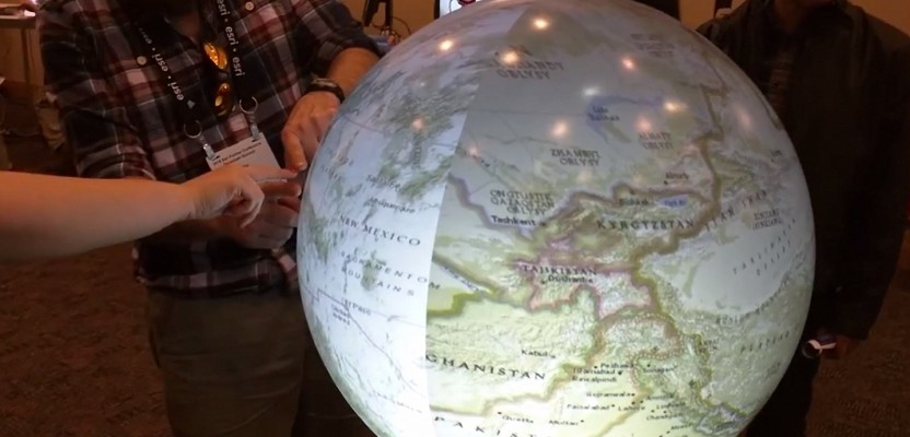
- The Pufferfish Sphere XL: this demo booth was always crowded—a 36-inch plastic screen was the display mechanism. It allowed finger gestures on its surface to rotate the display, enlarge the map viewing area, and so forth. I took a short video and posted it here.
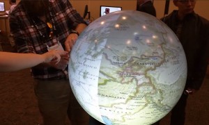
Pufferfish sphere


Other DevSummit videos are at this link.
Overall, I found the latest DevSummit to be very informative and enlightening as to Esri’s future web directions. I’m still more of an open-source fan as opposed to Esri’s ArcGIS Online’s walled-garden ecosystem. However, it’s tough to argue with numbers, and Esri is still #1 in the commercial GIS world, much as Apple is in its respective space. What’s truly ironic is that Apple has created many of its products using open-source technology (e.g., OS X is built upon the community-coded FreeBSD kernel), and then closing them off in sealed cases and protected by a fulltime staff of lawyers. Esri appears to be following the same model in web mapping, making open-source “keys” available (like the JavaScript API), but the keys only start up Esri cars. I’m not bashing good old American capitalism practices, but open-source is a wave that’s going to be hard to stop—sooner than later.