In ArcGIS Pro, why are my minimum and maximum Z values wrong, and how do I fix it?
Until recently, this isn’t the kind of question you would expect a GIS user to ask. Of late there have been many innovations in the geospatial software world, and the GIS user is now having to come to terms with real 3D geometry issues.
One question I’ve been asked a few times recently is why the Esri ArcGIS Pro software calculates heights for 3D features which are, on first glance, wrong.

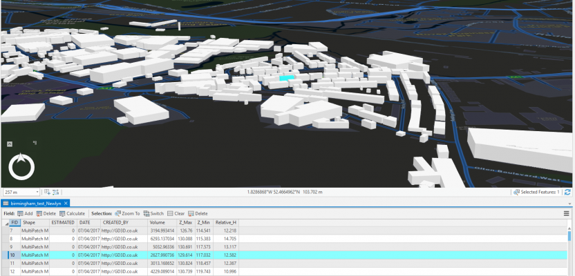
Example building reports height between 117m and 130m
When you run the “Add Z Information tool” in 3D Analyst or the “Calculate Geometry” in ArcGIS Desktop, you would naturally expect that, where the buildings are set on the ground, the minimum z value of the building would be 0 (zero), but this is not the case.

The “Add Z Information” tool
At this moment, any surveyors out there will be shouting at the screen, whereas many GIS users will be scratching their heads. You see, ArcGIS Pro and multipatches now use vertical reference systems (VCS), which means that heights given are above sea level (or the geoid, to the proper users out there). You can roughly verify this by Googling “Height above sea level Birmingham.”

Height above sea level for Birmingham, UK is around 140m
So, now that we understand the reference for the heights we can consider how to calculate the correct heights for these buildings. Let’s populate the data with the minimum Z and the maximum Z, then create a third field of Relative H. (You’ll want the t-shirt.)

Adding the Z_Min and Z_Max fields
Once we have the two Z fields calculated, we simply take one from the other using the field calculator. This will then give us the relative height (Relative H) to the lowest part of the building (0m).

Shows the relative height to the surface as “Relative H”