
A geospatial firm integrates open-source GIS and cloud services for the DoD’s IT security, a giant energy co-op managing 2,500 miles of transmission lines, and the USACE as they monitor dredging vessels.
Too often, clients maintain outdated and inefficient workflows because they fear that building applications to improve processes would be too time-consuming and expensive. Some are also concerned that new workflow applications will be resisted by users and possibly even management, due to fear of change or technology, further hampering growth and limiting profitability.
However, by leveraging various open-source tools and cloud-based enterprise solutions, efficient workflow applications can be created and configured to meet customer requirements. These applications can be adopted and tested quickly, leading to improved user input, greater acceptance among employees and management, and the ultimate goal—an effective and adaptable workflow.
“Open-source and cloud-based tools and solutions, as service options, will each save our customers time and money,” said Natasha Hartley, Woolpert vice president and geospatial team leader. (Woolpert is a national architecture, engineering, and geospatial firm.)
“Solutions such as these allow clients to become more productive and effective in fulfilling their mission since they will no longer spend valuable resources supporting infrastructure and applications.”
These applications are being implemented and evaluated as this technology unfolds, while multiple public, private, and governmental companies and organizations are beginning to realize expansive benefits.
Building the Foundation
Enterprise-solution technology is continually evolving, and multiple factors and applications continue to impact and refine that platform shift. Several companies, from software vendors to those who implement those solutions, have contributed to this process and created a solid platform that allows for upgrades and solutions.
One key contributor to the launch and continued success of this process has been Adobe. In 2012, Adobe announced the final release of its Flex software development kit (SDK), as well as plans to continue to support it through 2020. The SDK, which has since been renamed Apache Flex, was followed in 2014 by Esri’s final release of its ArcGIS API for Flex.
In 2015, Woolpert was working with the U.S. Department of Defense (DoD) on its information technology security policies and procedures. The team, drawing on its experience with software implementations and more than 50 years working with the military, discovered an efficient and reliable solution for geographic information system (GIS) tool continuity in the open source community that would be a great fit for the DoD—the JavaScript-based configurable web viewer (CWV), using the JavaScript API.
“This API was DoD-approved, so they could guarantee Configurable Map Viewer (CMV) continuity and support across all client platforms,” Hartley said. “It was a great example of how to best leverage a central accessible repository for secure and reliable information storage and application in this open source setting.”
The CMV, which is a widget-based application, was introduced to the open-source community via GitHub by David Spriggs and his team in 2015. Built with the Esri Java- Script API and the Dojo Toolkit, the CMV uses the simplicity of JavaScript and HTML5. Combined with its built-in widgets and plug-in-free, cross-browser compatibility, it enables rapid client-side development.
Another application that allowed Woolpert to customize and modify the CMV for its work with the DoD was the Web App Builder (WAB) for ArcGIS.
“This What You See Is What You Get app enables developers to use canned widgets and configure fully map-centric apps with minimal coding to expand their products with additional canned widgets,” Hartley said. “It’s easy to design and deploy these custom widgets to best meet the needs specific to each client.”
The WAB integration for CMV has opened the door to a wider range of widgets, making the viewer even more robust with little or no additional cost to the client. It has proved to be an asset and has saved time by freeing resources to fulfill custom requests for enhancements to benefit their customers.
The Woolpert team found that the WAB integration for CMV saves its clients money by using open-source technologies, enabling a thorough and efficient conversion of respective systems to the Map Viewer framework. It also minimizes the impact on client productivity, streamlines data by removing redundant processes, and enables hyperlinks to other applications. These include real property project and work-order management systems, etc., to use and geo-enable multiple authoritative data sources and visualize them through a single interface.
As it has developed, the benefits of open source software (OSS) have become increasingly apparent and applicable. These benefits include cost, flexibility, freedom, security, and accountability. Additionally, OSS has long-term viability and adaptability, which allows it to maintain its position at the forefront of technology.
Improving Electrical Distribution Management with GIS
A good example of the application benefits of OSS can be found with the PowerSouth Energy Cooperative, an electrical distribution management company that serves close to 50 counties in the southern U.S. PowerSouth was formed by 11 cooperatives in 1941 to generate and sell electricity and serves more than 1 million end users in 39 Alabama and 10 Florida counties. Its 2,000MW-generating capacity is supported by six generating facilities and 600 personnel, 21,000 structures, and 240 substations.
Two years ago, PowerSouth tasked Woolpert with implementing an open-source enterprise solution to upgrade the management of the approximately 2,500 miles of transmission lines it owns or for which it has easements. The data from these lines impacts PowerSouth’s tax responsibilities; how the company manages land maintenance like trimming trees; and how land boundaries are mapped for structures like the transmission lines, power poles, power plants, and substations.
The data also affects multiple groups—real estate, engineering, maintenance, planning, senior management, and board members—making it vital to the company’s profitability.Since this implementation, PowerSouth reports that it has drastically improved the efficiency of its evaluation process, eliminated data redundancy, established a trusted portal to access data, and heightened productivity.
“We have supported PowerSouth for over six years, and two years ago we helped them adopt the JavaScript application programming interface and open-source solution, which streamlined their transition from Flex to JavaScript,” Hartley said. “The GIS solution has become a portal to their company’s other applications, such as document management, outage, and inspections.”
The upgrade has eliminated the previous protocol of accessing multiple systems to get a comprehensive answer, which caused inaccurate results due to deprecated data. It also made the process of evaluating and repairing transmission lines less lengthy and cumbersome, according to PowerSouth business systems services supervisor Kenneth Jones.
“It used to be a very manual, labor-intensive process: the crew in the field would have to go out to inspect transmission lines, take notes on a clipboard, and fill out a paper form, bring those papers back to the office, have a maintenance supervisor evaluate them, and schedule maintenance or replacement,” Jones said. “We had stacks of paperwork to house, read, and analyze just so we could process that information and make decisions.”
This delayed the management of these lines as well as the data needed by each of the affected groups.
To address this and to ensure CMV end-user continuity in the new API environment, Woopert’s team cataloged all existing functionalities to create a comparative analysis of existing JavaScript API tools.
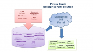
The PowerSouth Energy Cooperative illustrates the flow of information in its enterprise GIS database solution.
Woolpert worked with the PowerSouth team to merge all disparate data sources into a single enterprise database solution that would store all information related to engineering, CADD, GIS, document management, and maintenance. They also ensured minimal impact to the data stewards’ existing input and analysis systems, which include Oracle forms, document management software, GIS software (Esri, Google Maps), CADD software (Autodesk), and Web forms.
Data now exists only once in the enterprise database, with one structure table for engineering, real estate, planning, and maintenance, which will be accessible via a GIS map portal.
Through these tools, PowerSouth’s data now sources directly from the systems of record, eliminating redundancies, disparate data, and incorrect reports for senior management and board members. The CMV is now their trusted portal in which these systems can be accessed and viewed.
“The same process that used to take weeks or months is now instantaneous,” Jones said. “Now the crews go out in the field with a tablet, which is already loaded with the information they’re supposed to have when they get out there, and they can see themselves on the map, take pictures, and update the information about that line so it’s all stored on the device.
“When they come back to the office, they sync their tablet with the database, and the maintenance superintendents can group and analyze those projects.”
This solution also is cost-effective because it streamlines inventory management and provides a one-stop shop for frequently needed information.
“It saves money because it saves time,” Jones said.
As a transparent data source, the new process also allows more end users to view and validate data. This easy access improves processes for departments throughout PowerSouth, including land management, construction, right-of-ways, maintenance, structural design, etc.
Enterprise Solutions with Cloud Tech
The U.S. Army Corps of Engineers (USACE), Mobile District, is in the process of making its transition to the cloud for its National Dredging Quality Management (DQM) Program. The program is a partnership between the USACE and the dredging industry that provides automatic monitoring of the USACE’s dredging vessels.
The DQM system works by having onboard sensors monitor dredging activities, operations, and efficiency, and then routing that data to the USACE support center for retrieval and storage. Woolpert has been working with the USACE on this project and its multiple GIS components for about six years, gathering that data and building an enterprise database in Oracle to store it in house.
“Basically, this is a system in which every dredging vessel that the Corps is operating or is contracting with sends information to the system every six seconds,” said Jon Downey, Woolpert vice president and director of the firm’s partner geospatial sales team.
“The information all goes to a queue as a web service. We have written scripts that take information every five minutes, stores it in the database, and is viewable on the map viewer.”
The map viewer allows access to what’s going on with the vessel and for people to make decisions based on that information, and it allows these vessels to be monitored without disruption. “You can see exactly what that vessel is doing: Is it sailing? Is it dredging? Is it anchored?
You can see the salinity of the water, the speed, the displacement—a ton of things,” Downey said.
“The government can know at any given time if a vessel is dumping its dredge load, and, if it’s releasing that, the government can do alerts to reflect that. If it’s traveling and getting lighter as it goes, that likely signifies a leak.”
The data can also be used to improve business practices, ensure environmental compliance, and increase understanding of this science and technology.
Downey said that, due to the volume of vessels and the frequency information about each vessel being gathered, the data being stored already is in the hundreds of billions of records and continues to grow exponentially. To enable the USACE to store and retrieve this wealth of data, Woolpert used the Azure Cloud—Microsoft’s cloud-based solution—to build the environment necessary for the USACE to continue to access all its DQM data.
“We’re working with them on building the system that will mimic what we’re doing on in-house infrastructure,” Downey said. “There they can see the efficiencies to be gained from this big-data solution. It basically takes the originals of the information gathered and pushes it out to the big data storage solution to maximize data retrieval time and response time.”
Cloud services provide a single point of contact for technical solutions and offer transparent scalability, which tends to promote productivity. The response time should be the only difference end users see, Downey added, since nothing else about the process will change for those retrieving data.
“We’re going to use the exact same web interface that already exists,” he said. “We’ll just point people to the new service. That is a key aspect of the cloud’s functionality and eliminates the need to retrain end-users.”
Tools to Match Client Needs
The cloud-based DQM system is in the testing process, and the USACE is scheduled to complete the process of implementing the solution within the year. Downey said Woolpert selected the Azure Cloud option for this project because it best fits that client’s needs. The firm uses various public cloud services to deliver services-as-a-solution (SaaS) and solutions-as-a-service (SolaaS) as part of custom-built solutions.
Matching a solution with a service also can be a function of experience. PowerSouth had an emergency response widget prototype that initially was based on facilities. The Woolpert team repurposed that information and created a municipal emergency response widget to help demonstrate the CMV’s versatility.
By replacing the building point of view with parcel and tax record hyperlinks, the CMV accurately displays the status of facilities in an emergency or whether they have been notified of an emergency event.
This project, which also was tested in the DoD environment, was best served using the cloud technology on Amazon Web Services (AWS). Efficiencies enabled through AWS allowed the firm to build an instance that would mimic the environment and build the server within minutes. The open-source solution allowed it to work for parcels rather than facilities within hours rather than weeks.
“The key to this, as with any solution, is to find the tool that works best for you and your client,” Downey said. “Whether it’s Microsoft or Amazon or Esri or another cloud service provider, you use what’s best for your customer.”
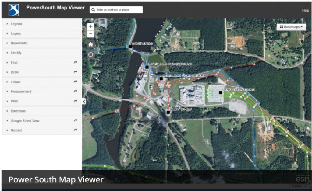
This screenshot of the configurable map viewer used by PowerSouth shows how the single enterprise GIS database can store and allow access to all information related to engineering, CADD, GIS, document management, and maintenance.
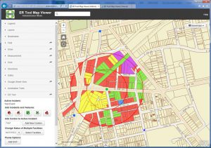
This repurposed emergency response widget was initially based on facilities but was converted into a municipal ER prototype widget to demonstrate the CMV’s versatility.
Clear Skies Ahead
Cloud-based and open-source SolaaS solutions, in multiple variations, can be a great option for clients because they remove the burden and expense of maintaining a server, software, and application infrastructure in-house. This functionality allows clients to have the specific tools they need to focus on their mission rather than on their infrastructure maintenance, and they can store and access vast amounts of necessary data.
As this technology evolves and applications increase, there are only more solutions to be realized. In the meantime, the key will be to build on success stories like those that are being realized by the USACE, the DoD, and PowerSouth.
Jones said his transmission line crews, who have been using the open-source data management system for about two years, continue to find value in this technology.
“I was surprised honestly by how much they’ve liked it, because not everyone loves computers or works with them every day,”
Jones said. “But I think they saw how important it was to the work and how it really impacted their jobs and made them better. The benefits are clear, and the ability for the crews to improve with these tools is empowering.” Jones said the process, implementation, and upcoming plans for cloud storage are a good fit for PowerSouth, and he can see the application benefiting multiple industries.
“I’d recommend it to anyone,” he said.