It’s as easy as 1, 2, built.
In my last article in this series (December 2015), I briefly discuss the essence of what a web map is and the basic components. This part looks at the easy web mapping solutions that I briefly touch on in the last piece. I then discuss and provide the knowledge you’ll need to create your own web map in the next article.
Build It and They Will Come
When choosing a web mapping system, consider not just the data, but also how you intend to share the information, because there are several ways to share.
Of course, the first way (and also most probably the reason you are reading this) is the simple web map. There are also embedded web maps, which is where you place the map within a web page like you would a graphic or image. This works well when discussing change or when the text requires context. Another way to share your “map” is through sharing the layers. Web Mapping Service (WMS) protocol allows you to share the data styled and attributed through an internet link for others to consume with their GIS.
To determine the best option, consider the audience. WMS works well with technical users, whereas a full web map is ideal for collaborative projects. Embedded maps work well for reports or situations where the map is there to support the text. This isn’t to say that you can’t mix it all up; some of best maps have been made by detouring from the norm.
Over the last three years, many “easy web map” options have become available on the market, each claiming to be free and to simplify the complexity of creating your own web map. Each has its own benefits, so, to save you from trialing them all, I’ve compiled my findings in the breakdown here. View this article online to click on each example map and play with it.
ArcGIS Online
This is probably the most popular web mapping option, as it comes free, bundled with ArcGIS. Clever marketing and a very simple WYSIWYG interface make it the easiest option for getting your very first map online, although costs can escalate quickly as they’re linked to page views, and who knows how popular your map is going to be?
ArcGIS is Online is the most popular web mapping option.
Pros:
- It’s extremely easy to create a web map.
- What you see is what you get.
- You have the ability to share as a web map embedded in a web page, or even share the data via WMS.
- There’s a customizable interface.
- You can use analysis functions.
- You can make maps entirely online or using the desktop GIS.
Cons:
- The price is confusing, based on “credits,” which is not wholly clear. The cost is based on views and functionality, but there’s no clarity over the scale.
- Your costs will be expensive if your map is popular.
- The free option is not secure for sensitive projects (all maps are posted for all to see).
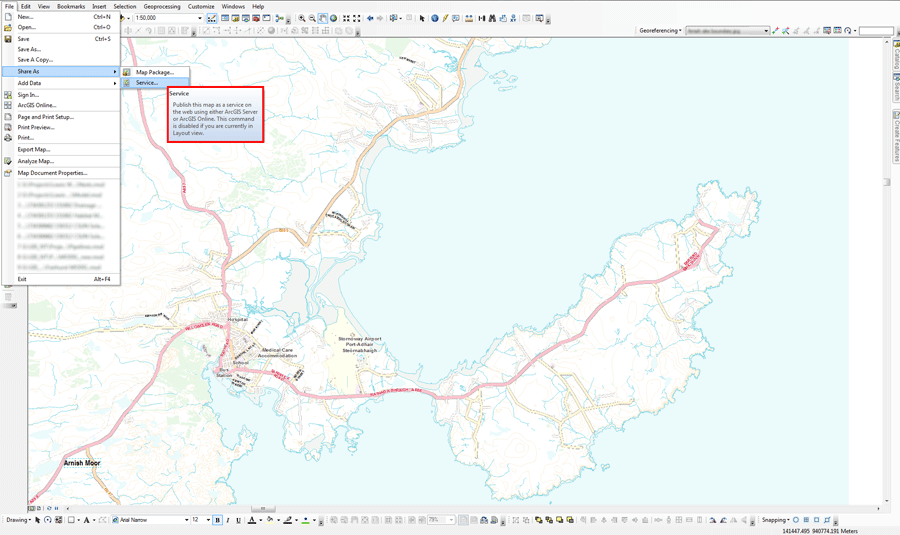
People often overlook that the Esri option is there. It’s a thing of beauty, fully integrated into the desktop software so that it works seamlessly, which for production purposes is ideal.
To use, you can simply make a map as normal within the software and then “send it to ArcGIS Online” using the Esri store, which renders your work on their online portal with all the styles and symbols that you set on the desktop, something that cannot be said for many of the other web mapping options.
This solution is ideal for all web mapping needs. There is no limitation as to whether you use an embedded web map, a full web map, or just WMS. Also included is the option to create “Story Maps” as well as customized interfaces. It is unfortunate, then, that it is relatively so expensive. Some would say you get what you pay for, but I personally find it hard to justify the cost.
Alternatives: QGIS Cloud
CartoDB
CartoDB is one of the many new systems available that sell themselves on providing a simple platform for getting your map or information on to the web with no need for a web page or anything else: just log in, upload your data, and away you go.
Like the Esri solution, it can handle many of the popular geospatial data formats like KML, Shapefile, CSV, and GeoJSON, but that is about all these two systems share in common. Based on PostGIS, the CartoDB system will store up to 50MB of data for free and allow you to create as many maps online as you like.
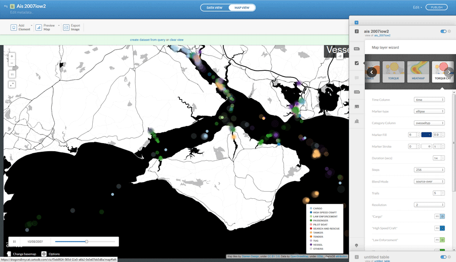
CartoDB allows for a time-base animation.
There is a plethora of basemaps and visualization options available, like the time-base animated option. All that’s needed is a CSV file with time-related data, and CartoDB does the rest.
The sharing options are not as generous as ArcGIS Online, but it does offer options to provide a full-screen web map or embed one within a web page. There is also the option to add your map to your visualizations via java script, which allows more customization (there’s a link to an example in the online version of this article).
Pros:
- It’s simple and easy to use.
- It has built-in visualization capabilities such as heat maps and temporal visualization.
- Options provide full-page or embedded web map.
- 50MB and your own web map are all included for free.
- It scales well between mobile and desktop formats.
Cons:
- The free option is not secure for sensitive projects (all maps are posted for all to see).
- Although there are lots of visualization options, it can still be quite limiting.
- There’s no WMS option.
- It’s limited to only four layers per map.
- The cheapest price plan is $29 for only 100MB storage (although that allows for private maps).
Alternatives:
MangoMap, Click2Map
QGIS Cloud
Tempted by the lure of the ArcGIS Online WYSIWYG whereby you just upload your map direct from your GIS to the web? Well, this one is for you. QGIS Cloud is a plugin tool for the popular open-source software, QGIS.
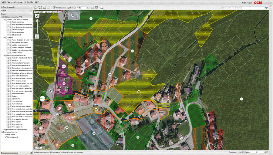
There’s no limit to the number of layers using QGIS Cloud.
In a similar fashion to CartoDB, data is stored on PostGIS databases, and storage is limited to 50MB for the free option. There is no limit to the number of layers, and you get a lot of functionality such as measure and identify tools.
Pros:
- It’s simple and easy to use.
- What you see is what you get.
- A professional set of functionality tools are included, such as search, identify, select.
- Options include a full-page or embedded web map.
Cons:
- The free option is not secure for sensitive projects (all maps are posted for all to see).
- Plans start from $73 per month for secure options (they allow 500MB).
- There’s no WMS option.
- Styling can sometimes be tricky (styles don’t always translate).
Alternatives: ArcGIS Online, QGIS2Web, QGIS2Leaf
OpenWeb GIS
Now for something completely different. On the surface, this is a web mapping system, although it could really be thought of as a virtualized GIS.
With the ability to use many of the popular geospatial data formats and spatial analysis functionality, this GIS can also call on weather and Wikipedia. There is really a lot to like about it. It’s a GIS system on the internet that you can save, and then you can share the saved map.

OpenWebGIS is more of a virtualized GIS.
The only real issue is that it is not a web map in the sense that you can host the code on your own web page easily. I say easily as there is an option to export the whole thing to javascript and host on your own website as is, although this option requires a little web know-how.
Put on an intranet, this makes for a great collaborative tool or GIS for a team who doesn’t want to commit to geospatial software.
OpenWeb GIS can be accessed via a link in the online version.
Pros:
- It offers lots of functionality.
- There’s a professional set of functionality tools such as search, identify, select.
- It’s entirely free.
- It uses most spatial data formats (and exports many also).
- It offers analysis options as well as weather and Wikipedia.
- It offers options to edit and manipulate data.
Cons:
- It’s tricky to translate to your own web site.
- It’s not very attractive.
- There’s no WMS or embedded map option.
Alternatives: ArcGIS Online
Although each of these systems sells themselves as free map options, there is a lot to consider in your usage and how you wish to engage with the intended audience. Each system has its own benefits and problems. In my opinion, the cheapest and easiest option is to build your own solution, which I will demonstrate in part three of this series.