“After all of these years, I’m really happy to be able to say that Autodesk is now truly in the measurement business,” says Pete Kelsey, Autodesk’s strategic projects executive. Though he was quick to add qualifiers to that statement: “We are not in the measurement hardware business, but we are now more closely aligned with measurement than ever before.”
Autodesk has always been in the measurement business, as the value of measurements is realized only if you do something useful with them. Even from its earliest days Autodesk’s products have enabled folks to take the measurements to plan, design, build, operate, and maintain—but now they can get more out of the new wave of mass-data-capture measurement technologies.
Pete is well-known to many in the Autodesk AEC (architecture, engineering, construction) user community, specifically the surveying and civil side. Pete is one of us, a guy who started out in the field and in front of the workstation; he even founded and served as CEO of his own technical services company. Since joining with Autodesk eight years ago, he has taught civil software suites, provided support for end users, performed with his band at Autodesk University, and served as one of the company’s technical evangelists (the actual title on his business card at the time). I asked about Pete’s new role as a strategic projects executive.
“There has been a serious effort by Autodesk to not fall into the trap of being just a software vendor,” Pete said. “We want to be more of a trusted business partner with end users. Our team seeks out large projects, big challenges, innovative stuff that might really be ‘out there,’ stretching the limits of what we do, and we learn from it.” Strategically, this makes sense. He adds, “We’ve developed [all of] these solutions to [manage projects and data] from field to finish. There are usually a lot more capabilities in the tools than most people use. We want to test and demonstrate the full capabilities.”
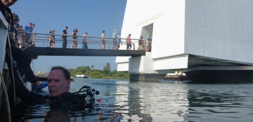
He provided some examples. “We [recently] worked with the National Parks Service on the first comprehensive survey of the USS Arizona Memorial [in Pearl Harbor] in 30 years. This is hallowed ground—the final resting place of 1,177 sailors and Marines—it is very important to preserve the site. Time, saltwater, oil leaks … a new survey [was] needed to help evaluate the conditions,” said Pete. “Thirty years ago, some amazing hand-renderings were produced. Now we are able to create full 3D computer models for analysis, simulation, and virtualization for education purposes. There are 1.8 million visitors per year; an NPS objective for the project is unlimited virtual visitors worldwide.”
Multiple non-invasive technologies were combined for the first time to capture the data, carefully and respectfully, Pete explained. “We used multibeam sidescan sonar, terrestrial lidar, subsea lidar, photogrammetry, and portable sonar.” He did some of the hands-on measurements himself. “We modeled in 3D a few artifacts from a series of underwater photographs; there was a Coke bottle from 1941 and a cooking pot in the galley area. We took the 3D models and replicated these with a 3D printer. At some point NPS hopes these will be displayed in the visitor center.” Pete explained another planned task for the 3D printer: “We hope to print a 3D version of the entire ship from the models we created, also for display.”
The reality data from the multiple sources was created using Autodesk ReCap (“reality capture”) software and then visualized in Autodesk Infraworks. “We used a wide range of solutions, but most of all it was truly an honor to be part of this project for the Park Service,” said Pete.
Pete has been involved in other proof-of-concept projects: scanning the Moai statues on Easter Island and coral reefs and shipwrecks in the Florida Keys and Micronesia, and he is planning another large project to scan, model, and analyze the iconic U.S. Air Force Academy Cadet Chapel. “The Air Force is a large consumer of energy,” Pete said, “and there is value in understanding how energy costs could be reduced in buildings, structures, etc. It will be a challenging structure to scan.” He explained that the multi-sensor approach will provide models that can be used for both the energy analysis and to determine required maintenance.
I asked what key lessons from his days in the field influence his current work. “I think that the training I got in the Army was the most important,” he said (he served as an artillery forward observer). “The trigonometry, the math we learned—it was made very clear that the most common mistake was calling fire in on your own position rather than the intended target.” He added, “We have to keep in mind that it is very important to have accurate measurements and calculations for everything we design and build. That is why I am thrilled that we are emphasizing measurement.”
“We’ve been working on ways to better integrate what I like to call the ‘big four’: lidar, sonar, photogrammetry, and GPR [ground penetrating radar],” said Pete. ”ReCap, ReCap 360 [a cloud service], things like Project Memento—the old hardware limitations are not as much of a worry anymore.” We joked a bit about the days when processing horsepower was a serious challenge, working old versions of CAD on “286s” and worse. “We can now truly tackle the ‘3D Elephant’—the old stuff was more like ‘2-and-a-half-D.’ Cloud-based processing and data sharing are really making a difference and removing all of the old limitations.”
Photo: Pete Kelsey, Autodesk’s strategic projects executive, did some of the hands-on measurement himself on a survey with the Park Service to evaluate the conditions of the USS Arizona Memorial at Pearl Harbor.