Part 1: An Introduction
Editor’s note: With this article we start an overview of GeoLearn courses offered by Dave Doyle, former chief geodetic surveyor for the National Geodetic Survey and geodesy editor of xyHt. GeoLearn (geo-learn.com) is an online education business helping professionals reach mandatory continuing education requirements and sort through everyday work issues. Dave’s series includes eight courses on fundamental aspects of geodesy and a ninth on tips for reading and understanding NGS datasheets. Here we’ll outline all his geodesy courses, but sign up if you’d like the full content.Surveyors, many times, treat geodesy as a “take it or leave it” topic. But with the increasing demands on positioning accuracy, the necessity of reporting information on a plane coordinate system, and ubiquitous use of technology that relies on GNSS, the ability to properly understand what to do and how to do it with modern reporting requirements makes it essential to understand geodesy.
As the types of surveys change, the need to understand geodesy can often mean the difference in being able to get the job done or not. And it may start with being conversant at a conceptual level with your client and stakeholders before getting the job.
Why Is Geodesy Important?
 More often than not, a client or state or local requirements mandate a connection to the State Plane Coordinate System (SPCS). The system was created to enable surveyors to work on large areas of the Earth and to be connected to a plane coordinate system without having to use geodetic surveying techniques. But that does not mean anyone can operate in total ignorance of geodesy.
Surveyors have a professional responsibility to achieve quality, accurate results for their clients. That means understanding all the processes, from research to field work to data analysis to conversion of surveying results to the resulting coordinates. Having a basic understanding of geodesy is fundamental to performing these steps properly.
This is especially true when surveyors combine any non-global-satellite technology with a satellite technology. Combining satellite-surveying-based data with data from total stations, lidar (ground- based, mobile land, marine, or airborne), and many other terrestrial technologies require manipulations of the observed data into a database in a common datum.
This is not as trivial as it sounds, and many surveyors, unfortunately, are content to press a button or select a menu option (the trained monkey syndrome) to have these operations done for them.
While nobody is advocating that surveyors understand how to do these conversions longhand, most surveyors do not even have a conceptual understanding of how the observations are converted. Without this understanding, knowing how data collection conditions limit the conversions leaves surveyors with exposure to liability. After all, we are selling accuracy, regardless of whether the survey demarcates property boundaries, results in a topographic map, or controls the layout of facilities in a major engineering project.
Additionally, the development of GPS and other GNSS provide us with the capacity to locate virtually anything, anywhere, at any time to within a few centimeters. This capability will increase positioning to the point of ubiquity, among not just surveyors but also many others who are not even aware of geodesy.
Being able to evaluate and explain what the measurement data means creates an additional professional burden to particularly understand geodesy, as all GNSS surveying involves geodetic mathematical processes. That’s because GPS and other GNSS are created to inherently first determine a 3D position on an ellipsoid of the Earth (such as WGS-84 or another ellipsoid relevant to another GNSS).
Surveyors need to understand the process of converting that first ellipsoidal position to one on the Earth’s surface or on a plane projection that has a well-known relationship to the ground. So, understanding the basic principles of physical (gravity field) and geometric (positional relationships) geodesy is vital to being able to accurately describe the vast amounts of high-accuracy positioning information that is being collected, shared, and used all around the world.
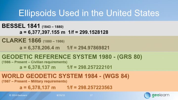 If you’ve tried to develop an understanding of geodesy and are drowning in concepts and terms like GRS80, WGS, NAD, and NSRS, you need to get all the basics organized in your head. The subtitle for this series of Fundamentals of Geodesy courses is Demystifying the Reference Frame. With the announced upcoming changes with the 2022 datum by NGS and the news that it will be referred to as the Reference Frame, this is a good way to begin that shift in understanding. 2022 is not that far off!
Intro Highlights
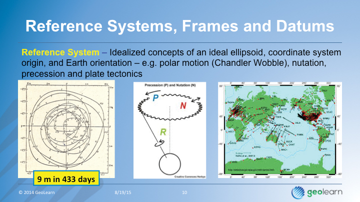
This introduction starts by reviewing the historical development of our knowledge of the size and shape of the Earth and the fundamental design of horizontal and vertical datums and their realization. It also covers:
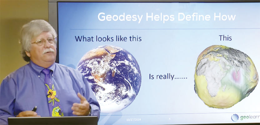
Why the Earth is not a sphere. Most of us know that the Earth is an irregularly shaped body that only looks like a sphere from thousands of miles away, but relating this understanding to the regular, mathematically defined ellipsoids is an important concept for surveyors on a practical level.
Early efforts to measure the size and shape of the Earth are described to give surveyors an appreciation for the great thinkers and experimenters who have preceded us and who contributed greatly, even when in error(!), to the body of knowledge we all partake of.
Why there are different ellipsoid models of the Earth is a question that is easily addressed when you understand how much the Earth is not a sphere. But still, the impacts on positions with changing models is an important concept to eliminate the “close enough” attitude that some take when faced with a choice on how to designate a datum associated with their positions.
 A brief overview of various types of geodetic datums. Yes, there are different types of datums. For example, with vertical datums, the first differentiator is tidal and geodetic. There’s a place for both.
Understand the phrase: “How datums are realized.” While the concept of a realization was not talked about much even a couple of decades ago, modern datums go through constant updates that must be fixed to a certain time or epoch. Knowing when a datum is realized and how it is realized is an important part of connecting to a datum, and also in publishing results.
Who is responsible for geodetic datums in the United States. Not everyone knows!
The science of geodesy is at the heart of all accurate horizontal and vertical positioning. Today, not knowing anything about geodesy is an invitation to a damaged reputation because a surveyor’s deliverables were not complete or accurate enough or because the surveyor was not able to provide advice with the deliverables that took geodesy into account. It’s time to learn.
The next article in this series covers classical horizontal datums.