
The National Geodetic Survey of the U.S. responds to surveyors’ questions on how legacy physical geodetic monuments will be affected by the planned 2022 reference framework modernization.
Editor’s note: A recent article in xyHt’s online newsletter, Field Notes, prompted a discussion among surveyors on the pending 2022 modernization of the National Spatial Reference System (NSRS) for the U.S. and its territories. Their questions relate to the role that “passive control” (physical geodetic monuments in the ground) will have in the new framework, considering the increasing reliance on “active control” (GNSS reference infrastructure).
The NGS was pleased to provide a detailed response as educational outreach for the 2022 modernization effort by Dr. Dru Smith, NGS NSRS modernization manager. Although these questions and responses are specific to the passive/active control systems of the U.S., other countries already have or will soon undergo a similar transformation of their geodetic reference frameworks and passive/active control infrastructure, so these issues are a hot topic with surveyors and geodesists across the globe. Furthermore, there will be repercussions for infrastructure engineering, GIS, and construction.
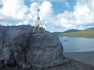
GPS equipment is set up over mark PAGAN 1 (PID AA5095) on the remote volcanic island of Pagan, Commonwealth of the Northern Mariana Islands, during a recent NGS survey aimed at determining the rotation of the Mariana tectonic plate for the purposes of defining MATRF2022.
In a recent article for xyHt, Scott P. Martin posed the question, “Are HARNs on death row?” The NGS thanks Scott for writing the article, raising this question (and others), and giving everyone a chance to consider what the modernized NSRS will look like, and especially what role passive geodetic control marks will play in the future.
In reading the article, one might gauge that the “question behind the question” is really, “What will happen to the HARN coordinates on HARN marks once NATRF2022 (and PATRF2022, CATRF2022, and MATRF2022) are the official reference frames of the NSRS?” Hopefully, this response will successfully answer that question behind the question.
As there was a great deal of information in Scott’s article, it seemed best to address topics in the order they were presented, with two exceptions: NGS will address the most important question first and then provide background and terminology to help put the response in context. After that, the article will be addressed in order, with closing discussion at the end of part 2.
Surveyor’s Questions
The most important question [posed by Martin in the original article] is:
“Should local, grassroots efforts be mounted to perform a campaign for submission to NGS through the Bluebook process or the successor thereto (part three of the Blueprint for 2022), to ensure that they will be included in NATRF2022?”
Yes please! NGS strongly encourages the re-surveying of historic marks. Because this is so important it will be elaborated upon at the end of part 2 of this article.
“[HARNs were] the first attempt to develop a truly three-dimensional system that included precise ellipsoid heights.”
The HARN surveys were definitely NGS’s first major foray into the new three-dimensional tool of GPS. But NGS was just coming freshly off of the creation of NAD83(1986) and wasn’t quite thinking three-dimensionally just yet.
Therefore, while it is true that HARN adjustments yielded some ellipsoid height information, the intent of the HARN surveys was really to improve latitude and longitude. As they were layered adjustments (GPS vectors first, then classical horizontal observations tied to that), ellipsoid heights were more of a by-product than a goal.
“The California High Precision Geodetic Network [is] HPGN, instead of HARN of course, we had to be different!”
This is a perfect opening to further address confusing terminology! Most of that was addressed at the top of this article, yet some additional history might be worth noting here.
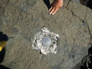
Geodetic Control Mark PAGAN 1 (PID AA5095).
In the early days of the HARN surveys, the terms High Precision GPS Network (HPGN), High Precision Geodetic Network (also HPGN), High Accuracy Network, GPS High Precision Network, and High Accuracy Reference Network (HARN) were used quite fluidly.
For example, Soler et al. (1992) use “High Precision GPS Network” (HPGN) to describe HARN surveys in Florida, Oregon, Idaho, Washington, Maryland, and Delaware. But in the same paper, they use the overarching term “High Accuracy Reference Network,” while the title of the paper itself refers simply to “High Precision Networks.”
In Strange and Love (1991), the term FBN never appears, while High Accuracy Network appears once and HARN appears 79 times. Contrast that with Milbert and Milbert (1994), where the term HARN appears once, HPGN never appears, and FBN appears 57 times. Obviously, NGS was somewhat inconsistent in the early use and interchangeability of these terms.
“The misfit between CORS positions and those of HARN/HPGN stations was exposed, analyzed, and ultimately aligned, with CORS as control.”
As mentioned earlier, this alignment to CORS required an entirely new round of state-by-state GPS surveys, occupying many of the original HARN marks. This second round of state-by-state surveys are known today as the Federal Base Network, or FBN surveys. This also includes Cooperative Base Networks (CBN) surveys, which were performed by NGS partners that were coordinated with FBN surveys. For all practical purposes they can be considered the same as FBN surveys.
Despite the early confusion between the various terms, most of the recent literature from NGS (from the mid 2000s and forward) will use HARN to mean the first round of state-by-state GPS surveys (adjusted with classical horizontal observations) and FBN to mean the second round of state-by-state GPS surveys (whose adjustments did not include classical horizontal observations).
The FBN surveys (1997-2004) differ from the HARN surveys (1986-1997) in three distinct ways:
- They used CORS as their primary control rather than relying on either published passive control or sparsely distributed International Earth Rotation and Reference Frame Service (IERS) fiducial stations.
- Accurate determination of ellipsoid heights was a primary goal of all FBN surveys.
- Only GPS data (no classical horizontal observation data) were used in the FBN adjustments.
An FBN survey was performed in 49 states (excluding Hawaii, D.C., and five territories) between 1997 and 2004.

(l to r) Dru Smith, NSRS modernization manager, and Brad Kearse, deputy director of NGS, answer questions during the 2017 Geospatial Summit.
In 30 states, the FBN adjustment yielded horizontal coordinates that were statistically close enough to the HARN horizontal coordinates (tolerances of about 5 cm were used) that it was not necessary to supersede those existing HARN coordinates.
In 19 states though, there were enough marks outside of tolerance that it was necessary to supersede the HARN’s horizontal coordinates. When this happened, a second “realization” of NAD83 was published for that state.
By way of example, the state of Ohio had a HARN survey in 1995 and an FBN survey in 2003. The FBN adjustment (2004) did not yield significant horizontal changes from the HARN adjustment. As such, the only realization of NAD83 in Ohio, between the 1986 original release and the 2007 national adjustment, is NAD83(1995).
However, in California (one of 19 such states), the FBN did yield enough horizontal change that a new realization was released. California, therefore, has two realizations between 1986 and 2007, being the HARN coordinates [that are NAD83(1992)] and the FBN coordinates [that are NAD83(1998)].
However, in nearly all cases, the ellipsoid heights from the FBN adjustment were either the first ellipsoid heights ever published on a mark or they superseded the few less-accurate ellipsoid heights that came from the HARN adjustment.
“So here we are in 2017, and HARN/HPGN stations are still of significant importance in many areas of the country.”
If what was meant here was the HARN marks, then NGS wholeheartedly concurs, and rest assured, if they were observed as part of the FBN survey, they will be part of the re-processing efforts for the TRFs of 2022. However, if this meant HARN coordinates, then the response is somewhat different.
If, in fact, surveyors anywhere in the western United States are continuing to rely upon HARN coordinates on a mark, they are at least two (and in California and 18 other states, three) generations of NAD83 realizations out of date.
The HARN coordinates were superseded by FBN coordinates (in 19 states) that were then superseded by the coordinates coming out of the NAD83(NSRS2007) national adjustment and finally the NAD83(2011) national adjustment.
Ever since the release of GEOCON (in 2011), users have had the ability to transform their geospatial data forward to the more recent realizations of NAD83. With the 2017 release of NADCON 5.0, that ability is now much simpler than with GEOCON.
Of course, such transformations should not be considered as a replacement for geodetic control, but they never have been. NGS has stated from the very earliest days of NADCON that the best practice for achieving higher accuracy is to readjust original observations to new control. Users who cannot do so, or choose not to do so, are welcome to use transformation tools such as NADCON that yield less accurate results.
Lastly, there is significant crustal deformation, subsidence, and tectonic movement in the entire western portion of the North American continent (not just in California), relative to the less deforming part of the continent. Therefore, reliance upon coordinates from the 20- to 27-year-old HARN adjustments in such a region must come with its own particular challenges.
“When the NGS computed the latest realization of NAD83(2011)2010.00, it was based on a multi-year CORS solution. Then, approximately 80,000 passive survey marks, including the HARN/HPGN that had been included in projects submitted to NGS going back to the early 1990s, were recomputed in relation for the CORS-only positions. So, the passive marks, or at least a more modern subset of them, were pulled along into the latest version of NAD83”
In addition to this statement it should be re-iterated that HARN coordinates [“NAD83(1992)” in California, etc.] were the result of a layered adjustment of GPS vectors (first) and classical horizontal observations (second). That means a HARN mark might never have been occupied by a GPS receiver at all. This is not the case for the FBN marks where all marks were exclusively observed with GPS in the FBN survey.
The Fate of Legacy Published Values
Hundreds of thousands of marks were established in the mid-20th century to define and provide access to NAD83 or NAVD88. Many have not had new observations performed by the NGS for 40 years or more.
Instead, new published positions (latitude, longitude, and/or elevations) have occasionally been recomputed using either a mix of classic optical horizontal data mixed with GPS (HARNs) or, for a few tens of thousands of marks, with new GPS alone (FBNs). Most coordinates in the NAD83(NSRS2007) and NAD83(2011) adjustments were not the result of collecting new GPS observations, but rather re-adjusting old (GPS only) observations. Since the FBNs, the classical optical horizontal observations have not been part of updating coordinates in the NSRS. The mark pictured above had new values established from 1999 GPS observations (by volunteers) adjusted by the NGS; many other marks in the same region, and across the country, have not been re-observed as recently.
To be continued in part 2.
Terms
It’s important to define eight terms that are used throughout this response. However, each of these should be taken with a grain of salt, as exceptions to many of these definitions exist, and the terminology used by NGS was somewhat inconsistent until the mid-2000’s (and in some cases, unfortunately, remains so).
Frankly, to get all of these details 100% clear and documented would require a significantly larger effort than what is written below.
HARN survey: a state-by-state collaborative effort between NGS and professionals within each state to collect GPS data on a set of passive geodetic control marks, with the intent of improving horizontal coordinates by leveraging GPS technology. These occurred between 1986 and 1997.
HARN adjustment: a three-layered adjustment for a state (sometimes a group of states), using both the GPS data collected in the HARN survey as well as existing classical horizontal observations. These adjustments resulted in HARN coordinates.
In general, each adjustment went like this, with each layer held as fixed for the next layer: A-order GPS, then B-order GPS, then lower-order GPS and all classical horizontal survey data.
Note that the marks in this third layer of the adjustment will be called “HARN marks” in my responses, just like in the first two layers, but if they had only classical horizontal data (no GPS), then they did not participate in the “HARN survey.” This third layer of the adjustment was sometimes referred to as a “statewide readjustment” (Milbert and Milbert, 1994.)
HARN coordinates: the published NAD83 coordinates on HARN marks, generally given a datum tag reflecting the year of the HARN adjustment (between 1990 and 1997). Note that coordinates on HARN marks that came out of the third layer of the HARN adjustment generally did not have ellipsoid heights, especially those HARN marks that did not participate in the HARN survey.
Within the HARN coordinates, one may speak of the HARN latitude, HARN longitude, or HARN ellipsoid height. Every point with HARN coordinates has at least a HARN latitude and HARN longitude, but only some have a HARN ellipsoid height.
HARN marks: that group of passive geodetic control marks with HARN coordinates. Such marks may or may not have actually participated in a HARN survey.

A frequently used Coast & Geodetic Survey (predecessor to the NGS) marker set in 1933, across the bay from Seattle.
FBN survey: a state-by-state collaborative effort between NGS and professionals within each state to collect GPS data on a set of passive geodetic control marks, with the intent of improving ellipsoid heights by leveraging GPS technology, especially by tying to the expanded CORS network and also applying “Height Modernization” techniques. These occurred between 1997 and 2004 and very frequently were performed on HARN marks. They were known as “HARN re-observation surveys” when they were actually ongoing.
They were sometimes also called the FBN/CBN surveys, where CBN means Cooperative Base Network (distinguishing FBN marks that the federal government would maintain from CBN marks that would be maintained by state and local authorities.)
FBN adjustment: a GPS-only adjustment for a state (sometimes a group of states), using the GPS data collected in the FBN survey. No classical horizontal data went into FBN adjustments. Depending on the outcome, these adjustments would yield up one of the following:
A) A triad (latitude, longitude, ellipsoid height) of FBN coordinates would be given to every passive control mark in the FBN adjustment. This happened only if a substantial quantity of the latitudes and longitudes of those marks were greater than 5 cm from their HARN coordinates. In this case, all three coordinates would be given a new datum tag.
For example: Wisconsin’s HARN coordinates are NAD83(1991) and their FBN coordinates are NAD83(1997). This happened in only 19 states.
B) An ellipsoid height would be assigned to all the marks in the adjustment (for some marks it was their first ellipsoid height ever, and for other marks this new ellipsoid height superseded the mark’s HARN ellipsoid height), but no change to the point’s HARN latitude and HARN longitude were made.
In this case, though this ellipsoid height is, by all rights, an FBN ellipsoid height, no datum tag was actually associated with this ellipsoid height in the NGS database. What this means, from a practical standpoint, is that these FBN ellipsoid heights would appear on an NGS data sheet with HARN coordinates. And since datum tags only appeared next to latitudes and longitudes [until the NAD83(2011) coordinates came out], the ellipsoid height could easily have been interpreted as having come from the HARN and not the FBN.
For example: Ohio’s HARN coordinates are NAD83 (1995), and though there was an Ohio FBN survey and Ohio FBN adjustment (in 2003 and 2004 respectively), there are no “Ohio FBN latitudes” or “Ohio FBN longitudes.” Before the 2007 national adjustment, a datasheet from an FBN mark in Ohio would show the HARN latitude, HARN longitude, and FBN ellipsoid height, but none of them would carry the tag “NAD 83(2004).”
FBN coordinates: either a triad (latitude, longitude, ellipsoid height) of published NAD83 coordinates on FBN marks, generally given a datum tag reflecting the year of the FBN adjustment (between 1990 and 1997) or just the FBN ellipsoid height that was published on all FBN marks.
FBN marks: that group of passive geodetic control marks that participated in the FBN survey.
To read previous articles on 2022, try:
- The NGS discusses the upcoming national spatial reference framework modernization.
- A Summary of the Modernized NSRS
- Passive Survey Marks Get a “Stay” under the NSRS
- Are HARNS on Death Row?
- Fundamentals of Geodesy
- A New Datum
- Gravity’s Increasing Gravitas
To read more from this print issue, click on the cover below.