Professional interdependency is at the core of this project for acquiring federal conservation easements and restoring wetlands in Tennessee.
Each item we touch these days has been shaped by a village of experts, from that cell phone in your pocket to the water coming out of the nearest drinking fountain. The surveying and engineering professions have long been familiar with this. Professional interdependency seems to be growing all the time as technology advances and the amount of components increase. With this shift, defining the roles and responsibilities and under which “hat” they fall is an ongoing challenge. As humans we seem to have an inherent need to know “who does what,” and as professionals upholding our obligations to the welfare of society we also need to be aware of “who is qualified to do what.”
In the United States Department of Agriculture – Natural Resources Conservation Service (USDA-NRCS), one of the programs that uses numerous specialties inside and outside the government is the Wetlands Reserve Program (WRP). USDA-NRCS works with landowners, land surveyors, and many others to purchase conservation easements. This article is about a project in Tennessee that involves an easement acquired under the programs outlined in the 2008 Farm Bill.
I am currently serving as a staff engineer in an area office of the USDA – NRCS. The State of Tennessee is divided into four areas, each of which has an engineering staff that provide services to the county offices. The easement programs are just one of the many federal programs for which I assist in developing engineering designs. The goal of all of the engineering documents that I develop is to conserve natural resources.
The majority of programs implemented by the USDA-NRCS are voluntary conservation programs implemented on private agricultural lands. The overall mission of the USDA-NRCS is to “help people help the land.” The main goal of the Wetlands Reserve Program (WRP) is restoring wetland function and protecting our nation’s agricultural wetlands through purchasing conservation easements under various terms of agreement: permanent easements, 30-year easements, and 10-year easements with restoration cost-share agreements. (As of this year, USDA-NRCS is currently working under a new farm bill that handles the conservation easements differently, so this discussion focuses on the programs as they were administered under the previous farm bill.)
The Wetlands Reserve Program Process
Step 1: Identifying Wetlands for Conservation
How do landowners know they have land that could potentially qualify for the WRP program? Resources include USDA-NRCS field offices and GIS
Dave McMillen analyzes the soil for wetland indicators to help determine program eligibility.
databases to run analyses that point to potential areas with a higher likelihood of having historical wetlands.
The USDA-NRCS has local district conservationists who are familiar with their geographic area, current and historical land use, as well as the USDA-NRCS program requirements. These local district conservationists do their best to disseminate information about the various programs offered by the USDA-NRCS across their county or counties.
Another outreach method was developed by one of the USDA-NRCS resource soil scientists, Dave McMillen, who is a member of our Wetland Team (I’ll introduce that a little later). The three main indicators for wetlands determinations are plant and animal communities, soil characteristics, and hydrologic characteristics. Dave developed a marketing plan to find a way to notify agricultural landowners that their lands may be eligible for this program centered on basic wetland indicators.
McMillen worked with USDA-NRCS GIS staff to use the Soil Survey Geographic
Database (SSURGO) to pull out information about potential hydric soil locations in Tennessee. A hydric soil is defined as “a soil that formed under conditions of saturation, flooding, or ponding long enough during the growing season to develop anaerobic conditions in the upper part” and is a characteristic of wetlands.

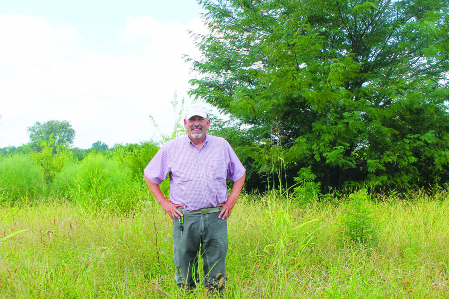
Jason McAfee works with the team to helped determine WRP eligibility and to develop a plan for restoration.
An analysis method for determining areas that met not only a handful of basic wetland indicators but also some program indicators was developed and implemented with the assistance of the GIS staff to find geographic areas of interest. Once those geographic areas of interest were determined, the GIS staff overlaid that information with a geographic database containing USDA program participant farm numbers, and then landowners associated with those farm numbers were mailed letters notifying them of the USDA-NRCS and its Wetlands Reserve Program.
There were additional nuances that went into the GIS analysis, but I won’t wear you out with too many details since we haven’t yet gotten to our main story.
Step 2: John Taylor’s Application for the WRP
This particular case study starts in Rutherford County, Tennessee with the district conservationist at that time, Jason McAfee, working with a local dairy producer and row crop farmer, John Taylor. Taylor had been working with the USDA-NRCS implementing various conservation practices on his farm in conjunction with USDA-NRCS as well as the Tennessee Department of Agriculture (TDA) for many years. Taylor wants to be a good steward and land manager, but the farm is his livelihood so he also has goals to ensure that he can earn a living. So, like with many federal/private landowner partnerships, we have many “cooks in the kitchen” with slightly different tastes.
McAfee was aware, based on his local knowledge of the location of the farm and land use, that Taylor’s land potentially qualified for the program.
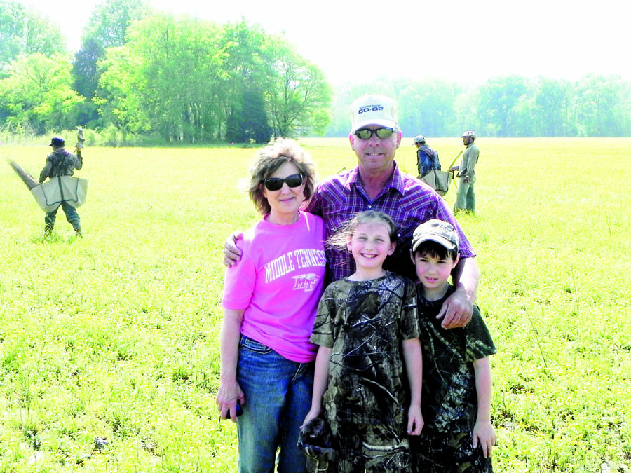
John Taylor (with his wife and grandchildren) is a dairy producer and row crop farmer; he strives to be both a good steward and a good manager.
Taylor’s farm is located near the headwaters of the Harpeth River, an area suspected to historically have had pockets of wetlands. Once McAfee knew that Taylor was actively interested in applying for the program, he sought guidance from the Area Wetland Team: the resource soil scientist (McMillen), a biologist (Chris Wolkonowski), and an engineer (Matt Brown; he comes into the story later). McMillen and Wolkonowski then visited the farm to look for wetland indicators in order to determine eligibility for the program and develop a preliminary plan for restoration.
The USDA-NRCS goals regarding wetlands delineation are slightly different than what’s done for mitigation purposes. The aim is to restore the wetland function to an area that appears to have historically been a wetland and has been altered over the years, usually for agricultural purposes. Because the federal government is acquiring an easement and wetlands don’t usually follow lines that are convenient for retracement and conveyance purposes, the program allows a one-to-one matching. So if, upon performing their delineation, the resource soil scientist and biologist find that there are approximately 50 acres of suspected wetlands, the landowner can be eligible to apply for up to 100 acres to restore as wetlands and make an easement boundary that is more opportune for conveyance and retracement purposes.
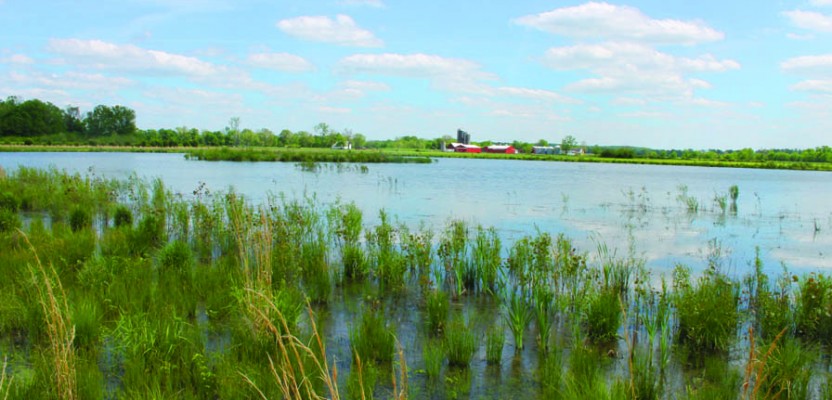
Taylor’s fields after having been recently flooded.
At their planning visit, McMillen and Wolkonowski made note of other items such as ingress and egress, plant species present, and visible hydrology indicators. Sometimes the areas of interest are not adjacent to public roads, or only a portion of the land is eligible and that portion is not adjacent to a public road. The federal government needs to be assured that it will be able to access the easement, especially in the cases of permanent easement acquisitions like Taylor’s. The wetlands are delineated, and all of this information is noted so that a restoration plan can be developed and the needs can be relayed to the surveyor for the easement acquisition.
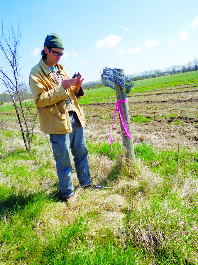
For most easements, because the delineated wetland will not be the actual boundary of the easement that will be purchased, the wetland is not delineated to a high degree of accuracy. Also, the boundary line for a wetland can vary, so it is a bit of a moving target to begin with. Our resource soil scientist for this particular project happens to be savvy with GIS equipment and software, so he will simply use a handheld GPS device to store waypoints and create a point shapefile, which he will bring into ArcGIS. Then he and Wolkonowski develop their wetland restoration plan with the goal of restoring wetland function to Taylor’s site.
Step 3: Easement Survey and Acquisition
Now that the resource soil scientist and biologist identified that Taylor’s site has restorable wetlands and have developed a plan for restoration, Taylor filled out an application for the program. Taylor’s application ranked high enough based on programmatic criteria that it was funded, so the next step
Chris Wolkonowski is the expert on the plant and animal habitats to be reestablished.
was to go through the process of selling an easement to the federal government. This easement acquisition is led by the USDA-NRCS Tennessee State Easement Program staff.
This staff consists of the wetlands coordinator, an easement specialist, and additional support staff. They worked with the USDA-NRCS contract specialist to hire a private survey firm to perform the survey of the easement and to prepare the documents necessary to record that easement. At the same time the Easement Program staff worked on the easement acquisition, the Area Wetland Team came back and finalized Taylor’s Wetland Restoration Plan. (If you’re a federal employee or work with the federal government, you know that we like our acronyms; the restoration plan is lovingly called the WRPO, pronounced “war-poe.”) The actual construction of this WRPO is done once the easement acquisition process is completed.
The survey firm awarded the contract is L.I. Smith & Associates, Inc. based out of Paris and Nashville, Tennessee, and they worked with the NRCS and Taylor to determine the desired location for the easement. If it happens to be convenient, the USDA-NRCS likes to make the easement line coincident with the retraced boundary line. If this is not possible, then the next best option becomes lines of occupation between farm fields, fences, or creeks. There are times that this isn’t possible, either, and only a portion of a field may be delineated for the easement. It just depends upon the particular scenario that the wetlands team, landowner, and surveyor are faced with. Most of Taylor’s easement lines were surveyed to be coincident with existing property lines and field fences. Also, a field road was surveyed and an ingress/egress easement was purchased to access the easement, as it did not adjoin any public roadways.
Matt Brown establishes the shallow water areas and completes the engineering documents.
Once the easement survey was completed, which included marking all lines in the field as well as preparing a survey plat and easement description, those necessary documents were provided to the Easement Program staff. They continued to work with the land surveyor, national legal staff, title companies, and the local counties to complete all of the paperwork required to finalize the recording of the legal documents and to make the final payment to Taylor for the purchase of easement. Again, I’ve skimmed over many details in this process; a lot of this could be detailed articles in their own right.
Step 4: Restoring the Wetland
Now that the federal government has purchased a permanent conservation easement from Taylor, the resource soil scientist, biologist, and engineer worked together to implement the restoration plan (WRPO). A restoration plan usually consists of various elements such as areas dedicated to shallow water, tree plantings, native grass plantings, etc. The delineated wetland and the final easement boundary aid in determining what can be done to restore that wetland function to the site. All restoration plans are site-specific based on the processes that have come before and will often also include input from the landowner with their goals related to wildlife and hunting interests.
The engineer’s main responsibility is to establish the shallow water areas under the guidance of the biologist. The biologist is the expert on the type of animal and plant habitat we are trying to reestablish through this restoration process (animals and plants, like us, are particular about their habitat and what they will need to survive and hopefully thrive).
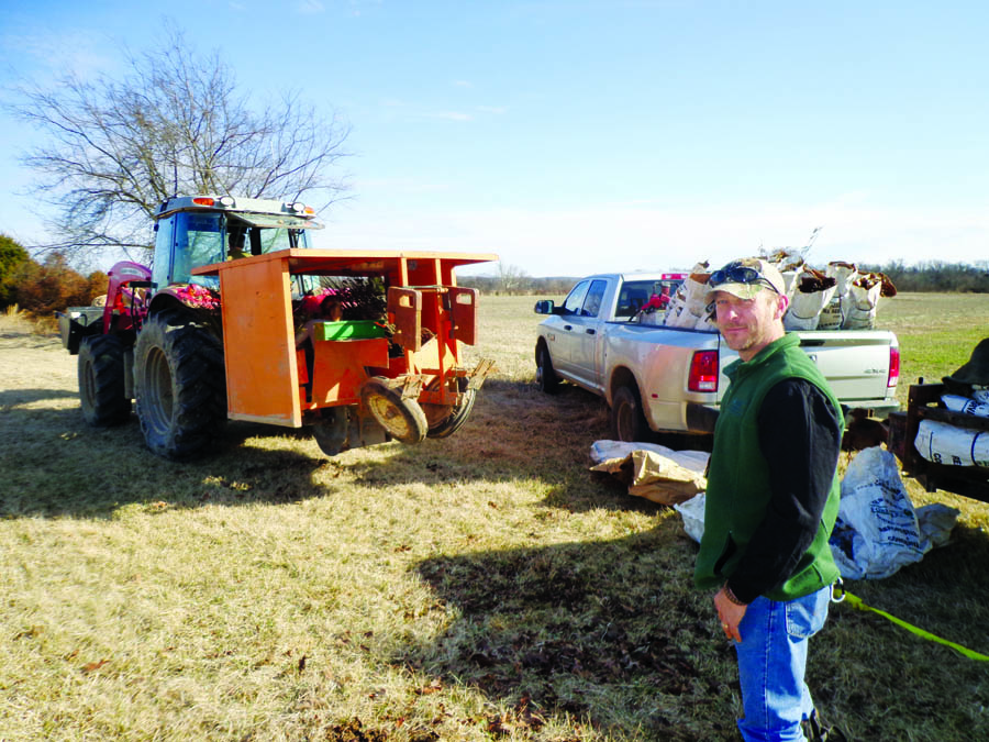
With the restoration plan in hand, the engineering staff traveled to Taylor’s site and performed an engineering survey to develop the design documents to recreate the hydrology on the site necessary to aid in restoring wetland function. Taylor’s restoration plan for the shallow water development was to plug a couple of field ditches and dig out a couple of shallow areas and spoil excess material in the center for a “goose island” (a technical, fancy term, I know).
Once the calculations were done regarding the watershed coming into the site, the amount of pool area desired, and where and how much water will leave the site based on a particular design storm, the final construction plans were drafted as well as various supporting documents (they can include but aren’t limited to construction specifications, a bid schedule, and government cost estimate). The federal government is responsible for paying for the construction of the restored wetland, so the goal is to produce a design that is economically conservative to the taxpayer and optimizes the protection of our natural resources as the particular site location and details will allow.
The engineering documents for Taylor’s project were completed by the local area engineer, Matt Brown, and his support staff (which now includes

Jorge Ramirez and Mike Roberts, Area 2 engineering staff, collect data to develop the engineering plans.
myself, but I didn’t officially join this staff until after Taylor’s project was complete). Now that the final engineering documents are completed, we’re back to working with our NRCS contract specialist, who assisted us in hiring our survey firm earlier. This time, we’re working with our contract specialist to request bids from contractors to perform the work specified in the engineering documents.
Once the process of hiring a contractor was completed, the construction of the shallow water areas began. In some situations, the other parts of the WRPO (tree plantings, native grass plantings, food plots for various critters, etc.) are completed prior to the construction of the shallow water area. Again, it just depends upon the site and the most efficient way determined to get everything completed to meet the final goals outlined in the WRPO.
Step 5: Permanently Conserving Our Natural Resources
Now we come to our end product that has taken the efforts of multiple specialties over several years. We’ve worked with farm bill program specialists, GIS specialists, resource soil scientists, biologists, conservationists, land surveyors, contract specialists, engineers, contractors, and probably several other support staff that I’m forgetting. The federal government has now acquired a permanent conservation easement across a portion of Taylor’s land, and after a few more years we hope to have a functioning wetland.
So in the end, what has the public gained from all of this effort on Taylor’s farm, and why is restoring wetlands im portant? The permanent easement ensures that the land use will remain a wetland and will no longer be managed for agricultural purposes. Restoring the wetland function is important to the Earth’s ecosystem. One of the most important keys to our survival is water, and, like the “freshwater mussels” of our rivers and streams, wetlands perform an important job of filtering our water. They also provide habitat for approximately one half of all North American bird species, even though wetlands account for approximately only five percent of the continental U.S. land surface (“Restoring America’s Wetlands: A Private Lands Conservation Success Story” USDA-NRCS Publication available online). Also, wetlands offer flood protection, sequester carbon to reduce greenhouse gases, protect cultural resources, and can reduce soil loss. These are just a few of the ecological benefits (of which we are aware) that our wetlands provide to us.
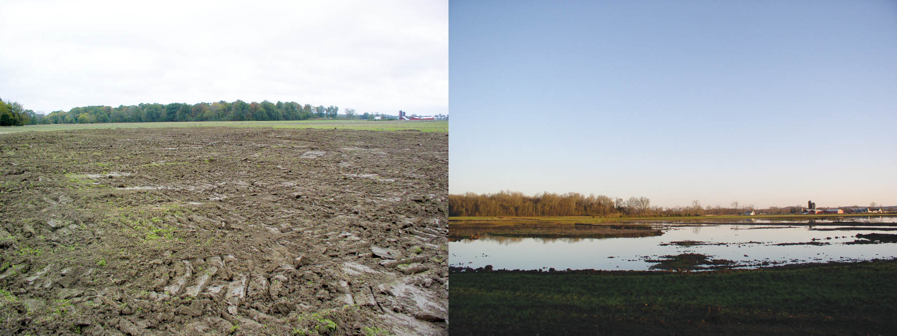
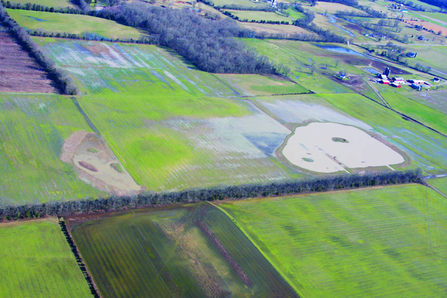
Taylor’s farm after excavation to create a pool area; right: after flooding.
Taylor’s wetland restoration and easement acquisition also provided an economic benefit to all of those involved in the process. Taylor was paid for the purchase of the easement, and all those involved in the process were compensated for their services as well. Sometimes the process works smoothly and other times we have many hiccups along the way as with any project, but in the end we’ve learned from each other and conserved our natural resources.
A wetland can be an interesting metaphor for much of the interdependent work that we do these days. Each of the specialists involved in accomplishing the task of acquiring the easement to restoring the wetland function depend upon one another to perform their jobs, like we depend on the wetlands to filter our water, to provide habitat for animals and plants, and to reduce runoff in our watersheds.