Tag Archives: ADUS DeepOcean
Surveying a Mile Down
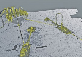
Above: The metrology viewed as a combined model. A 3D surveying company provides highly detailed lidar data on subsea drill centers. This article almost didn’t happen. I first met with ADUS DeepOcean in January 2017, when we discussed how they had captured high-resolution laser data deep in the ocean off Ghana. Today, four months later, I...
Deep-sea Mobile Mapping
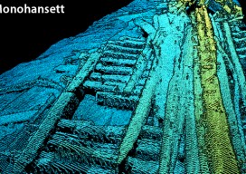
We’re all familiar with lidar-based mobile mapping from ground vehicles, and most of us are aware that aerial lidar is being used effectively to do shallow-water mapping along coastal and riverine projects. Deep-water lidar mobile mapping from an ROV? Well it’s a first for me. Most all of the subsurface surveys I’ve read about were...