Tag Archives: as-built
Handheld vs terrestrial lidar for building documentation
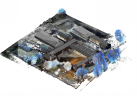
Sponsored by Paracosm Above: nmcn’s final CAD model as generated from PX-80 data. The 3D model is situated in the topographical point cloud data. Are these new tools accurate enough? Handheld mobile lidar scanners have gained market share in recent years by offering faster capture in GPS-denied indoor environments, easier documentation workflows for large, complex spaces,...
Easy Park Datasets
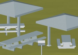
Above: Isometric view of 3D model of centralized benches, barbeques, and gazebos at Prescott National Forest. Collecting lidar data for as-built plans opt a busy national forest recreation site The Prescott National Forest (PNF) is a 1.25-million acre United States National Forest located in north central Arizona, with more than 20 developed recreation sites and an...
Choosing the Right Data Capture Tool for BIM
Above: This 3D image shows vertical measurements of the CUNY Applied Science Research Campus, where Bradford performed a 3D as-built measurement of all the recently constructed slab edges across six floors of the two new buildings. With the rise in demand for fast and accurate 3D construction information, laser scanning has become invaluable to many...