Tag Archives: auv

Q&A: 10 Questions with Hydrographer Helen Stewart
Helen Stewart is a multidisciplinary hydrographer with primary focus and expertise in multibeam sonar data processing, including experience in nautical chart surveying, scientific seabed mapping, pipeline inspection, geophysical survey, subsea survey work with both AUVs and ROVs, and geotechnical survey work. How did you get interested in hydrography. Did a specific event trigger your...

xyHt Weekly News Recap: 04/28/2023
Topcon Launches Easy-to-Use Building Construction Software Digital Construction Week Reveals Main Stage Lineup OGC Requests Public Comment on a Standardized Deformation Model and a Geodetic Data Grid Exchange Format AUV Helps Locate World War II Ship 80 years After Tragic Sinking Bluesky and Ecopia Partner to Create First 3D Map of Ireland Get Special Hotel...

New Digital World Needs Data
Next-generation surveyors require specialized education and training to fill the role of geospatial data specialists. Many emerging geospatial applications, such as digital twins, 3D modeling, monitoring, virtual reality, and autonomous vehicles, are based on big digital datasets. Building a 3D digital world starts with accurate data that ties to a point on the ground, so...
xyHt Weekly News Recap: 6/30/17
CompassCom to Debut Enhanced CompassTrac Enterprise Mobile Resource Management Solution at Esri User Conference Teledyne Optech brings full spectrum of remote sensing technology to Esri UC 2017 Applanix and the University of Waterloo Collaborate on Advanced Guidance and Control Technologies for Autonomous Vehicles Deepest Underwater Consumer Drone from Blueye Robotics Reveals Ocean Depths Previously Unseen...
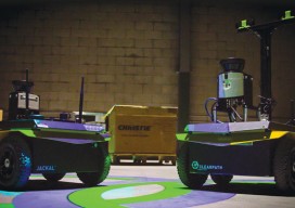
Robot Revolution
Clearpath Robotics CEO Matt Rendall discusses unmanned systems, land survey, and robotic industry trends. The robot revolution is hitting a big milestone. Robotic use is expanding beyond research activities, aerial applications, and industrial manipulators through a new kind of deployment: the service robot. These robots are autonomous, they’re geospatially aware, and they can manipulate...

Robots to the Rescue
Above: A representative from The German Federal Agency for Technical Relief operates a UAV. The potential for unmanned vehicles conducting search and rescue is proven in Southeastern Europe. Editor’s note: In our January issue we highlighted ways unmanned aerial vehicles are being used worldwide (UAVs for the Whole World), including for conservation, at high altitudes, and...