Tag Archives: BLM

Gerald Davis
Chief Cadastral Surveyor, Bureau of Land Management Arizona, USA Gerald (Jerry) Davis is a CFedS (federal surveying certification) panel member and professional land surveyor licensed in six states. Davis began his surveying career with the U.S. Marine Corps as a geospatial intelligence specialist. After retiring from the Marines, Davis went to the private sector where...
The DPPS Controversy
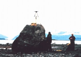
Why NALS should oppose the direct Point Positioning Survey (DPPS) policy outlined in the letter from NLM director Kornze to the governor of Alaska. (One Nevada surveyor’s opinion.) By Carl C. de Baca Some 86% of Nevada is comprised of Public Lands, and of that 60.8 million acres, according to the BLM’s own website, an...

Retracement: The Hidden Corner
The Art of Retracement The Old Man–Glenny Dale–paced slow and steady, picking his way through the ankle-bending sagebrush while enjoying its sweet, springtime smell. Eager (The Kid)–Igor Kidinsky–took a straight path along the old barb fence, crushing the twisted sage stems with solid stamps of his boots, lacking the patience of the old-timer. Four white-tailed...

xyHt News Links: 7/15/16
Sentera launches fixed-wing Phoenix 2 imaging UAV BLM’s new GNSS protocols may set undesirable precedent NEW Nautiz X2: comfortable, compact and rugged Google to provide raw GNSS measurements HYPACK 2017 – Registration Is Now Open NGRAIN Announces New App Enabling Deployment of Industrial 3D Content Creation – Epson Smart Glasses DJI Introduces First Integrated Aerial...
Level Up Your BIM!
BIM is soon to be mandatory for certain public works contracts in the UK, driven by expected cost-benefits. We asked a UK geospatial design expert (and xyHt contributor) to give us a look at what a few years forward may hold for BIM on this side of the pond. If you didn’t know already, the...