Tag Archives: CAD
The Case for Software Training
Getting the most value from construction software means knowing how to thoroughly use it. Gone are the days in the construction industry when a smart owner/operator and his backhoe could handle most projects. Back then, measurements were close approximations, and quality was achieved through the skills and experience of the hired contractor. Today, contractors and...

Protecting Your Eyesight – at Your Desk
I use special glasses to reduce eye strain in my screen-centric workplace. The geospatial industry has evolved greatly over the last decade, and with the current evolution of our systems this trend shows no sign of slowing down. We are seeing more and more of what has traditionally been considered fieldwork being brought into the...

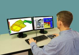
3D Software, Not Really Like CAD at All
Above: InfraWorks 360 uses engineering rules to ensure that vertical and horizontal curves in infrastructure elements have the proper radii. Take a close look at Autodesk’s InfraWork’s 360, an unusual 3D modeling software. Editor’s note: For many firms and practitioners of surveying, photogrammetry, mapping, and remote sensing, traditional deliverables to AEC clients have focused on...

xyHt Magazine November 2016 Issue
Click here to view the November 2016 issue of xyHt magazine.

xyHt News Links: 6/10/16
Tallysman Expands its Geodetic Antenna Line CHC launches high-end GNSS receiver for science, surveying Establishing orthometric heights using GNSS — Part 7 Topcon announces global Agriculture Group SETTOP BATTERY II: Safety and high performance for your surveying instruments. FARO Releases High-Resolution 3D ScanArm for Reverse Engineering and CAD-Based Design Applications Topcon introduces new Professional Services team...
xyHt News Links: 5/27/16
3D Laser Mapping Launches New Multiplatform Mapping System Hi-Target Qpad X5 high-precision rugged tablet Settop CellXtrem: Create your own CORS solution or connect to existing CORS trip services Congress yanks funding for OCX Iridium launches alternative GPS PNT service MicroSurvey Introduces the HxIP Imagery Program FARO® announces the release of PointSense & VirtuSurv 17.0: Point...