Tag Archives: geodude
Early 3D Scanning Competition: 1998 – 2000, Part 13
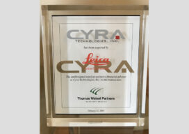
When you join a start-up, as I did in 1998 with 3D laser scanning pioneer Cyra Technologies, you worry about two things. One is if your start-up’s “new thing” will catch on in the market and your company will survive. The second is if a competitor will “out-invent” you with something better (and your company...
The Early Days of 3D Laser Scanning: Part 11
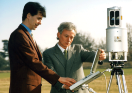
In 1998 I joined a small start-up, Cyra Technologies, which was pioneering 3D laser scanning technology. I had a senior product marketing role, reporting to the CEO.
The Early Days of 3D Scanning, Part 6
1998: Launching 3D Laser Scanning into the Market I had the good fortune to be deeply involved with a pioneering vendor of 3D laser scanners and point cloud software. As I consider where that technology is today – a multi-billion dollar per year industry, the valuable benefits it has delivered to so many organizations and...
Navigating the World of Point Cloud Software
Here’s advice on how to understand various functions that point cloud software may need to perform, keys to look for in each, and sourcing options. When you’re working with laser scanning, choosing point cloud software can be challenging. Challenges For newbies, the challenge is determining the best software to start with. Your existing CAD or...
Walkaround Mobile Scanning Part 2
Above: A backpack type of walkaround mobile scanning system was used to capture this site for a standard topo survey. Credit: Wantman Group Inc. Part 2: Applications and addressing challenges In Part 1 of this two-part article, I noted that walkaround mobile scanning is being rapidly adopted by the market. I described it in general...
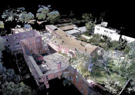
Life after the Little BLK360 Scanner’s Big Splash
Above: A “new-user” 1-person firm scanned this complex historic building in five hours with 75 set-ups of the BLK360 and created final drawings. Credit: Southwest Scanning. Almost everyone is familiar with splashy announcements of new products. For much of my career with Trimble and with Leica Geosystems, I personally drove many product introductions, so I’m tuned into...