Tag Archives: hurricane relief

Aerial Imagery to the Rescue
Events in 2017 demonstrated without any doubts or reservations how vitally important georeferenced aerial imagery is in assessing damage and supporting relief efforts following a natural calamity. Last September, an impromptu consortium of companies in North America mobilized their forces and collected and analyzed mountains of data at near cost to help out in what...
Wind, Water, and Fire: Hurricane Response in the Geospatial Community
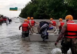
Response, recovery, and rebuilding in the aftermath of hurricanes Harvey and Irma and the unprecedented wildfire season in the West may be the largest combined U.S. disaster response to date. The impacts to Texas, Florida, the broader Gulf Coast region, and many western states will require large national and international effort. We are all involved;...