Tag Archives: Psomas
Geospatial Data United
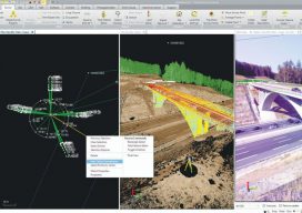
Industry trends are moving toward consolidated environments for data visualization, processing, and management. From the title you might get the impression this article is about a soccer team. To geospatial professionals, however, the title phrase could describe an ideal situation—the ability to handle all geospatial data in a common software environment. A soccer team is made up...
James R. Nicolau, IV
Project Manager for Land Surveying and 3D Scanning at Psomas Surveying’s “ambassadors” to related professions and industries help elevate the stature of the profession; James R. Nicolau serves in such a role. As the son of a business owner and professional land surveyor, James was introduced to the profession at a young age. With every...