Tag Archives: quantum spatial
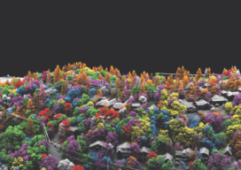
Fusing Data on Doomed Ash Trees
By using fused data gathered with lidar and hyperspectral imaging, a geospatial services company helped a large utility to identify 90% of ash trees with the potential to fall into their power lines—in a timeframe that wouldn’t have been possible without the use of remote sensing. By Ian Berdie, Zach Raymer, and Mia Chen Remote-sensing...
Assessing the Potential
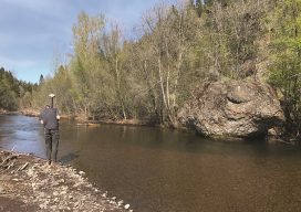
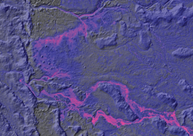
UAS-based Topobathymetric Lidar Surveys Understanding stream channel and floodplain morphology is critical for a number of efforts—from hydraulic modeling and stream-restoration design to aquatic habitat assessment. These applications require description of conditions both inside the channels and in the adjacent riparian zones. Gathering these data has typically relied on individuals on the ground or in...
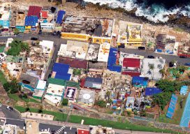
Aerial Imagery to the Rescue
Events in 2017 demonstrated without any doubts or reservations how vitally important georeferenced aerial imagery is in assessing damage and supporting relief efforts following a natural calamity. Last September, an impromptu consortium of companies in North America mobilized their forces and collected and analyzed mountains of data at near cost to help out in what...
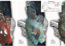
HSI on the Fly
One company details mapping applications of airborne hyperspectral imagery for agriculture, forestry, and resource mapping. By Patrick Burns and Scott Nowicki, PhD Remote sensing imagery has been collected with many different camera systems for many different applications over the past 50 years of the industry. Visible remote sensing imagery provides interpretable information available to most...
Thermal Imaging Heats Up the Geospatial World
Thermal Infrared (TIR) remote sensing technology makes existing applications more cost-effective and creates new applications, including for the environment. News footage frequently shows a dramatic scene of a suspect hiding in the shadows on a pitch-black night. Despite the darkness, the subject glows white-hot in the video recorded from a police helicopter’s thermal infrared (TIR)...