Tag Archives: rtk

What’s Inside Your GNSS Rover? Part 3
The third and final installment of a look at the inner workings of high-precision surveying rovers. In parts one and two, which appeared in the two previous issues, we focused on antennas, amplification, housing, channels, boards, and gates. This installment continues with signal matching, positioning engines, and additional components. Matching Signals To distill the observed...

xyHt Weekly News Recap: 05/12/2023
Phase One Takes Aerial Imagining to Another Level GeoBusiness is Back for 2023 USGIF GEOINT Symposium Set for St. Louis May 21-24 Vexcel Offers Access to High-Resolution Imagery in Australia and New Zealand Neusoft and HERE to Provide More Competitive Global Navigation Solutions Trimble Introduces RTX Positioning Solution for Package Delivery Applications via Drones WGIC...

Surveying for Safety at Waipio Valley
Lush vegetation, beautiful ocean vistas, and a historic Hawaiian valley provide the setting for a complex engineering project that addresses technical and cultural concerns. The Waipio Valley on the island of Hawaii has great historical significance within Hawaiian culture. Known as the Valley of Kings, it was home to many generations of the royal family...
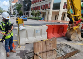
Disruptive Lidar Tech
Technologies developed for autonomy and consumer applications are opening up new user segments and rewriting conventional workflows A construction inspector sweeps their phone over an open trench creating a 3D as-built of the utilities within. This is just one example of low-cost, rapid, simplified reality capture is challenging conventional wisdom on how reality capture should...

An Exemplary Real-Time GNSS Network
For more than 20 years, SWEPOS has consistently demonstrated the full potential of real-time GNSS networks Standing in the main control center of Sweden’s real time GNSS network (RTN) system, I feel like I could be standing in NASA Mission Control. A marvel of infrastructure created by Lantmäteriet, the country’s mapping agency, the center has...
xyHt Weekly News Recap: 11/05/2021
Geo Week Keynote Speakers Announced NV5 Geospatial Extends Leadership in Canadian Hydrospatial Market Fighting Fires with Satellite Communications and Infrared Mapping Bell, Esri Deliver Integrated Smart City Ecosystem to Empower Canadian Communities MARACOOS, MARCO to Expand Ocean Mapping and Research Partnership Pix4D Launches the viDoc RTK in USA and Canada Geo Week Nominations for Excellence...