Tag Archives: SenseFly
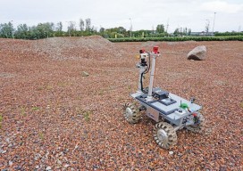
Robots for ExoMars: Drones and Space Exploration
Drones are being used to test a space rover in familiar ways. By Martin Azkarate UAV manufacturer senseFly talked to Martin Azkarate of the European Space Agency about his work developing rover prototypes for planetary exploration, including how he employs a senseFly drone to test these cutting-edge robots. Martin is a space automation and robotics...

xyHt Weekly News Links: 04/28/17
Teledyne DALSA previews its versatile and advanced LWIR camera platform at AUVSI Juniper Systems releases the Mesa 2 Rugged Tablet with Android O INTERGEO 2017 | SMART CARTOGRAPHY : How old-fashioned navigation aids have been transformed into today’s smart maps Octopus ISR Systems Integrates VectorNav GPS/INS to Develop Precision Geo-Lock Feature for Epsilon Series Gimbals...

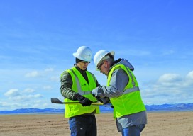
Markets for Geospatial 2017: Part 2, Infrastructure
President Trump’s plan for investing in America’s infrastructure calls for $1 trillion in spending over the next ten years. The specifics of the plan are still a work-in-progress, but with largely bipartisan support, chances are that there will be a big push on infrastructure projects in the coming years, and that should translate into significant...
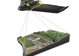
UAS: Measuring for Solar
Above: The Mortenson team prepares their senseFly drone for flight. With a UAS, a construction firm finds value—in addition to what can be measured—in real-time assessment and data availability. Surveying plays a crucial role in construction, from initial planning to final as-built verification, often in multiple phases. However, terrestrial survey methods come with challenges for...
UAS Surveying without GCPs
The subject of applying direct georeferencing to UAS platforms was a recurrent theme at the 2016 Commercial UAV Expo last week. Direct georeferencing offers the possibility of mapping without the use of ground control points, providing UAS operators a significant advantage in terms of speed. As an example of this technology, we reached out to...
xyHt News Links: 10/21/16
Teledyne Optech announces new efficiency enhancement for ALTM™ Galaxy wide-area lidar mapping sensor Canon Launches the Océ PlotWave 550 Print System Designed to Greatly Enhance Large Format Technical Document Management AVEVA and AEGEX partner to deliver Digital Asset solutions in Hazardous Environments Rwanda Launches World’s First National Drone Delivery Service Powered by Zipline UAV Drones...