Tag Archives: SenseFly

xyHt News Links: 10/7/16
GeoSLAM (handheld laser scanning) and Blackdog Robotics (unmanned robotic vehicles)partner for remote surveying in hazardous environments/uneven terrain TerrAvion Launches First Aerial Imaging Solution Specifically Designed for Rangeland Trimble Changes Name to Reflect Company’s Technology Evolution Teledyne Optech to introduce new static and mobile surveying solutions at INTERGEO 2016 senseFly to Unveil new RTK/PPK-Ready, Large Coverage Mapping Drone at INTERGEO 2016...
xyHt News Links: 9/30/16
Trimble Launches New Portfolio of Wireless IoT Sensors for Water Monitoring DAT/EM Releases Version 7.3 Orbit GT to launch Mobile Mapping v17 at Intergeo, Hamburg Geodetics introduces mobile mapping system with lidar, GPS senseFly and Maptek sign agreement around data collection and analysis solution DroneDeploy Speeds Up Drone Mapping for Remote Users With Limited Internet...
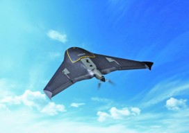
The UAS Platform, and How to Pick One
Secrets to Successful Selection Think UAS platform selection is cut and dried? Well, did you know that fixed-wing UAS, not multirotor, are the best fit for a specific (and growing) inspections market? Or that by choosing an amped-up multirotor UAS, your fee schedule could also get amped-up? Now that FAA Rule 107 is the law...
xyHt News Links: 9/2/16
Satlab New Product Announcement: SLC Handheld Four land surveyors share their experiences of using professional drones in their work. Airobotics Selects SimActive’s Photogrammetry Software for its Automated Industrial Drone Solution Carlson Software Releases BRx6 GNSS Receiver New Kespry Drone 2.0 Has Twice the Aerial Coverage senseFly launches new drone Property Drone Consortium and Marion County,...

Shark Week at Pangaea
With Discovery Channel’s “Shark Week” taking a big bite (sorry couldn’t help it!) out of my 4th of July weekend, my thoughts naturally turned to unmanned systems. Well, actually, thoughts on how unmanned systems are being used to study sharks with an eye to protecting both them and humans. Let’s start with that last application,...

senseFly’s Andrea Halter: From Academia to the Market
Above: This eBee Ag is outfitted with the Sequoia multispectral sensor. An interview with senseFly’s Andrea Halter Andrea Halter is a co-founder of senseFly, a Parrot company based in Switzerland that develops and produces aerial imaging drones for professional applications. Halter oversees the company’s marketing and sales teams. She’s a qualified land surveyor and holds a...