Tag Archives: traverse
GNSS & Educational Equations: A Grid-to-Ground Project
When planning GNSS control surveys on highway projects, it is important to understand the limitations of GNSS. Most highway projects are long, and linear distances that are wide open horizontally and vertically and are ideal for GNSS surveying. However, in rural and city areas, tree canopies and high-rise buildings will obstruct the GNSS signals, so...
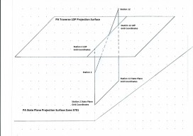
A Pennsylvania Traverse Low-Distortion Projection
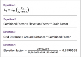
This article coincides with the December 2014 xyHt print article, Transformation of Observations – Part 2. In the September 2013 issue of Professional Surveyor is Dr. Charles Ghilani’s excellent article entitled “Grid versus Ground.” The article demonstrates the error created by ignoring elevation in traverse computations and describes the numerical and logical errors inherent...