Tag Archives: uas

xyHt Weekly News Recap: 10/21/2022
Teledyne Announces Ladybug6 Cameras for High Accuracy 360-Degree Spherical Image Capture Hexagon and LocLab Work to Accelerate Adoption of Smart Digital Realities Vexcel Imaging Introduces UltraCam Eagle 4.1 Photogrammetric Aerial Camera System Phase One to Launch New Calibration Center at Denver Headquarters Soaring Eagle Technologies Receives Long Distance FAA Waiver for UAS Inspections Common Ground Alliance...
UAS and ALTA Surveys – Part Two
Surveying firms that have been successful in incorporating UAS data in ALTA surveys adopt best practices to ensure precision standards are met. Plan, execute, and check. In Part One of this three-part series in the September xyHt issue, we looked at the time/cost/precision proposition of using UAS for elements of ALTA surveys. Firms interviewed agreed...
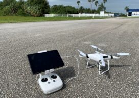
UAS and ALTA Surveys – Part One
Recognizing that with the right equipment and practices, specifications for ALTA surveys can easily be met, surveyors have rapidly adopted UAS for these and many other types of surveys. The adoption of UAS in the surveying profession has been more rapid than some past tech. It was only 2016 when the FAA Part 107...
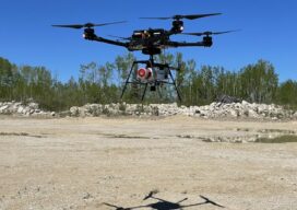
Fusing Aerial and Mobile Lidar Data
Creating accurate as-builts of a complex facilities is no longer a long-term project. When the Caltech Group was founded by two men in Calgary, Alberta, in 1990, they set out with the goal of becoming Western Canada’s go-to company for geomatics services with an eye on specializing in the oil, gas, and utility areas—those companies...

xyHt Digital Magazine: May 2022
Like a good surveyor, xyHt’s May issue covers a lot of ground, bringing you stories about UAV/UAS, Lidar, Aerial Imagery and Mapping. As always, if you don’t have a subscription to our print edition, or if someone else in the office has snaffled your copy, don’t fret, here is the digital edition. Click here or on...
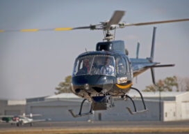
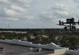
When a Drone Just Can’t Do It
There is a growing ebb in the tide of UAS adoption for aerial surveying, mapping, and remote sensing—finding the right balance between manned and unmanned aerial operations Unmanned aircraft systems (UAS), remotely piloted aircraft systems (RPAS), or just plain old “drones”—call them whatever you wish—have had a tremendous impact on geospatial industries. A decade ago,...