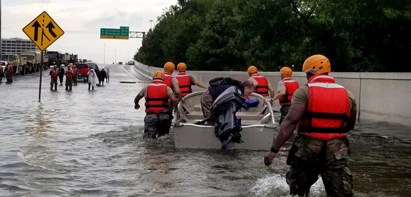
Response, recovery, and rebuilding in the aftermath of hurricanes Harvey and Irma and the unprecedented wildfire season in the West may be the largest combined U.S. disaster response to date. The impacts to Texas, Florida, the broader Gulf Coast region, and many western states will require large national and international effort.
We are all involved; we are the “us” in Houston, actively or passively, directly or indirectly. Surveying, geomatics, and geospatial professions (and related industries) are working on these efforts and will continue to long after the wind, water, flames, and public attention have subsided.
Although the focus now is on recovery and rebuilding, an essential role of geospatial professionals is providing data to inform better design and decision making to help lessen the impacts of future natural disasters—this role cannot be overemphasized despite going unsung.
Here are just a few of the growing list of responses from the geospatial community; details on these and more responses are on page 14.
The National Society of Professional Surveyors (NSPS) Foundation Disaster Relief Fund originated when Hurricane Andrew stuck Florida in 1992. The fund provides direct assistance by request for fellow surveyors. The fund is intended for the immediate needs of daily living for those affected by a disaster, such as food, clothing, lodging, and medicine. The Foundation is a tax-deductible 501 (c)(3) organization. Instructions on how to apply for relief funds or to donate are here.
MAPPS, a national association of private-sector geospatial firms, has highlighted the work that many of its member firms have been providing in response to Harvey. Said MAPPS executive director John Palatiello,
“These are just a few of the many examples of the private geospatial profession making technical and professional assistance available.”
They include TerraSond Ltd, Woolpert, Surdex Corporation, GeoCue Group Inc., The Sanborn Map Company, Esri, and Vexcel Imaging US, LLC.
No one will forget the unity this crisis has fostered and the heroic efforts of first responders, non-profits, private firms, and individuals. The geospatial community has already stepped up to help. We hope it can move forward to provide leadership in initia- tives to modernize flood mapping (maybe moving entities off flawed datums nearly a century old) and to rapidly provide better and more complete geospatial data to prepare for the next unthinkable event.
My personal plea in this season of multiple crises is for us all to stick to the data and facts. Surveyors and geospatial practitioners deal in real data. Please, resist exploiting the multiple crises to foist different agendas. Don’t post hurtful memes or disparage others. Let unity be the approach to such disasters.
As a former U.S. president commented,
“When the waters rise, so do our better angels.”
To read the rest of the articles in this print issue, click on the issue cover, below.