All posts by Annie Ellis

xyHt Weekly News Recap: 07/16/2021
Esri Releases New Predictive 2050 Global Land Cover Map Esri Awards GIS Users for Innovations Velodyne Lidar Partners with NVIDIA Metropolis for Infrastructure Solutions Zoom75 & Zoom 95 – The New GeoMax Robotic Total Stations Lidar Helps Reveal Radiation Hot Spots at Chernobyl GIS-Pro 2021: October 3-6, 2021 Setting the Record Straight: The RETAIN Act...

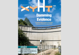
xyHt Magazine Digital Edition: July 2021
xyHt's July issue features Geographic Information System and the impact it is making on the modern world.

CZMIL SuperNova is Changing Bathymetric Lidar
CZMIL SuperNova, Teledyne Optech’s next generation bathymetric lidar system, is changing the way information about coastal territory is collected and processed. Terratec AS, a leading Norwegian mapping firm, is the first private company to acquire the CZMIL SuperNova and the only company in the EU to engage in work around environmental change and coastal zone mapping...
xyHt Magazine Digital Edition: June 2021
xyHt's June issue features hydrography and the need to survey everything water related.

MAPLand Act Gathering Support
The Modernizing Access to our Public Land (MAPLand) Act, which would direct federal land management agencies to digitize and standardize mapping records, has won the support of the National Society of Professional Surveyors (NSPS). The legislation, H.R. 3113, will allow hunters, anglers, and millions of other federal land users to access essential information about public lands...
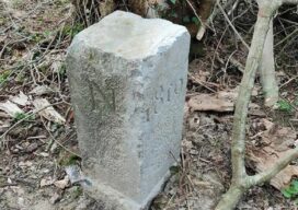
Farmer Accidentally Changes France-Belgium Border
Usually one country moving into another country’s territory is a huge geopolitical deal, often followed by military action. But when a Belgium farmer accidentally moved his country’s border into French territory, everyone just had a good laugh about it. The farmer was apparently annoyed by the boundary stone as he plowed his field, so he...