April 2017 Archives
Retracement in the Land of the Free
Art of Retracement By Warren D. Ward, PLS “I have to walk like a moose through this stuff!” claimed Glenny Dale, known on this crew as Glutton, The Old Man, because of his old legs. He had found a game trail that gave him about eight inches of flat path. But he had to tightrope his […]
Cadasta: Mapping Land Rights from the Bottom Up

Above: Staff of the Kenya Land Alliance review a sketch map with community members while mapping water resources in Tana River County, Kenya. Credit: Hilary Ogina, Kenya Land Alliance. Cadasta helps put people on the map with a cloud-based platform for land-ownership data. By Matteo Luccio In advanced industrial countries we take much infrastructure for […]
Strategic Movement: Precise Monitoring in Practice

A Danish company builds a successful monitoring business by leveraging technology and expertise. By John Stenmark, LS Newton’s laws of motion tell us that nothing moves if it isn’t pushed or pulled. That concept is behind the success of LE34, a Copenhagen-based surveying company that has built a business strategy around structural monitoring for a […]
Neutrino Beam! Scanning a Ring Tunnel
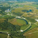
The surveying challenges for construction related to a particle accelerator are exacting—but surprisingly familiar. By Matteo Luccio Trillions of neutrinos from the sun and other celestial objects pass harmlessly and unnoticed through our bodies each second. These tiny particles are among the most abundant in the universe–a billion times more abundant than those that make […]
Leveraging Point Clouds

Above: This image illustrates the transition from point clouds to modeled deliverables. These non-BIM solids were later used for com-putational fluid dynamics analysis to ensure proper airflow throughout the room. Three ways you can derive value from point clouds past the pre-design phase. By Daniel Chapek Reality capture is a powerful way to digitize the […]
HyperStacking GPR

A new technology shows promise for enabling users to see deeper targets and operate in noisy conditions. By Jeffrey Feigin, PhD Editor’s Note: The field of ground-penetrating radar (GPR) is experiencing a new wave of development. For many of our readers, first impressions of legacy GPR gear included a lot of limitations and confusing images. […]