Tag Archives: Modelling
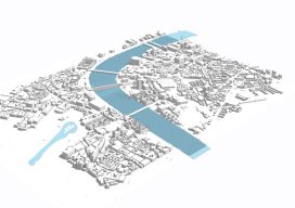
Esri CityEngine: What Is It?
These past few weeks I’ve been trying to do some clever augmented reality stuff with Unity involving putting an object on the floor and ensuring it doesn’t wobble when you walk around it. (Yay for SLAM in mobile devices.) Although in software like Unreal and Unity you can download or buy models, what do you...
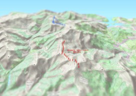
Create an Awesome 3D Map in Minutes in #QGIS
Until recently, 3D has been a bit of a gimmick to the everyday GIS user, by this I mean that it has been quite time consuming to create a GOOD 3D representation (easily) until now. I’ve used some great 3D software whilst working on survey data and also visualisation of environmental impacts, Fledermaus, ArcScene, Sketchup,...