Tag Archives: QGIS2Threejs

Why 3D GIS Is the Future
“The world we live in is a three-dimensional world, so why do we map it and analyse it in just two dimensions?” —Dragons8mycat, 2013 In the last five years, we, the GIS industry, have made some fantastic advances. So, why is it that we are so slow with the adoption of using 3D data? Surveyors...
Further Adventures with 3D GIS
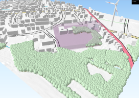
Last year I posted about this awesome plugin called “QGIS2Threejs” [here] and how it was possible to quickly render 3D visualisations for free using the open source GIS, QGIS. At the time I fudged some wind turbines as it was impossible to import models. Furthermore, I avoided too much detail as any imagery would look...