Tag Archives: satellite imagery

Sponsored Content – OneAtlas: Processing Satellite Imagery in the Cloud
Airbus Intelligence provides users with access to satellite imagery, innovative geospatial analytics, and industry-specific insights. Image data from the Airbus Constellation of satellites, which includes twin SPOT 6/7, Vision-1, Pléiades, and Pléiades Neo satellites are used to deliver actionable intelligence to a variety of markets around the globe. Already known for quick processing and delivery...
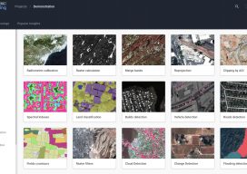
New EOS Platform Lets You Run Image Processing Tasks Online
Sponsored Content by EOS Data Analytics Most of your image analysis tasks that required ENVI or Erdas Imagine software are now available online thanks to EOS Platform. This new game-changing cloud service launched by EOS Data Analytics provides GIS professionals with a one-stop solution for search, analysis, storing, and visualization of large amounts of...