Tag Archives: analysis
Smart Maps Guide COVID-19 Investigations and Actions
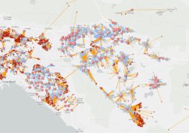
As hundreds of millions of eyes stay glued to the rising toll and reach of the novel coronavirus disease 2019 (COVID-19), map-based dashboards have become a compelling, near real-time way to monitor the outbreak. They’ve also substantiated the message that everyone must take precautions and alter daily interactions. When the World Health Organization (WHO) declared...
Big Data, Public Data
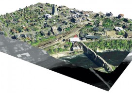
Above: A lidar-derived elevation raster DSM (of Dinkytown, MN) draped by an aerial photo. Free Aerial Lidar, Renewable Energy, an Infectious Mentality At the intersection of renewable energy, big data analysis, geospatial technology, and public data availability stands the Minnesota Solar Suitability Analysis project. Primarily manned by students in the University of Minnesota Master’s of Geographic...