Category Archives: Lidar/Imaging

Between the Scanner and the Deliverable: How Mach9 is Building the Missing Layer in Geospatial Production
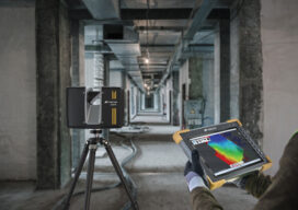
A Carnegie Mellon-trained roboticist who learned surveying in a coal mine and mapped uranium deposits inside decommissioning pipes is now building what he calls a new category of software — one that sits at the intersection of CAD, GIS, and the physical world. Alex Baikovitz did not set out to build CAD software. He set...
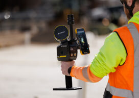
Topcon Expands Capture Reality Portfolio with Introduction of New Handheld Scanning System
Topcon Positioning Systems has introduced the CR-S1, a handheld scanning system that combines LiDAR, panoramic cameras, visual SLAM cameras, and a GNSS antenna in a single device. The CR-S1 utilizes Topcon’s Collage mass-data software ecosystem central to a connected workflow. The CR-S1 expands the company’s Capture Reality portfolio as a higher‑performance option alongside the CR‑S2....
Vexcel: How a Camera Company Turned Itself into a Global Data Engine
From film scanners to hybrid camera-LiDAR systems and a 43-country data program, Vexcel’s CEO Alexander Wiechert described the journey leading to the current product line in a conversation with xyHt at INTERGEO in Frankfurt. By Richard Thomas, Executive Editor Walking past the Vexcel booth at INTERGEO 2025, you see Merlin, Osprey 4.2, Condor and Dragon 4.2 front...
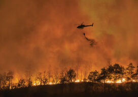
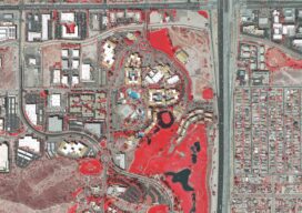
Fire Season Preparedness: GIS Powers Southern California Sheriff Departments’ Evacuations
The deadly Los Angeles wildfires that claimed 30 lives, destroyed 15,000 structures, and burned 37,000 acres in January 2025 forebode Southern California’s year-round risk. Rugged terrain, fierce winds, and prolonged drought have made more intense fire occurrence the new normal—and unified first responder coordination a matter of life and death. At least four million California residents live in...

Jack Dangermond’s Vision for the Future
The geospatial industry is moving through a period of profound transformation. Advances in reality capture, artificial intelligence, and cloud integration are converging with urgent global challenges, from climate resilience to urbanization. In this moment, few figures are as influential as Jack Dangermond, founder and CEO of Esri. For more than fifty years, he has guided...
Topcon 2.0: Reclaiming the Geomatics Frontier
For decades, Topcon has been a trusted name in precision optics, GNSS receivers, and machine control. Its equipment became a familiar sight on survey crews, construction sites, and agricultural fields across the globe. Over the past decade, the company leaned heavily into high-growth sectors such as machine control and precision agriculture, expanding its presence in...