Tag Archives: ArcGIS Pro
Calculating Geometry outside ArcGIS Pro
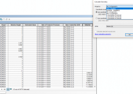
Let’s be clear: this isn’t a stab at the all-new, singing and dancing Esri software. This post is meant to help those who are using the software on a regular basis but finding issues with using the fields with multipatch data. Recently I’ve been working with calculating volumes of buildings that are multipatch data. For...
Multipurpose GIS with ArcGIS Pro
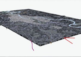
You can now use point clouds and massive geospatial data with GIS through the web and your desktop with new software. Above: London rendered in 3D with London Underground data. For years, point clouds (lidar, laserscan, and multibeam) have been pretty useless to GIS users. When a GIS user had to analyze the data, often...