Tag Archives: open source

Weekly xyHt News Links: 6/16/17
RIEGL has received the Sebastian Sizgoric Technical Achievement Award at this year’s JALBTCX conference in Savannah, Georgia. Record attendance for GEO Business 2017 Identified Technologies Aligns with DJI to Offer Best-in-class Commercial Drone Solution Survey and Mapping Company Partners with Leading Unmanned and Manned Flight Service Experts Aeroscout launches UAV helicopter for high-altitude flight Congress increases funding...
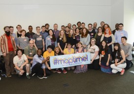
First Ever Maptime Summit
By Katie Kowalsky @katiekowalsky www.katiekowalsky.me It’s been over two years since the State of the Map US 2013, where Maptime was born. As of the first official Maptime in San Francisco at the time of the Maptime Summit (Monday June 8th), we now have 60 chapters spread over five continents. That growth, all from volunteers...

Esri Developer Summit 2015 Highlights
The 2015 Esri Developer Summit (colloquially referred to as the “DevSummit”) was held in Palm Springs, CA, March 10-13. Two thousand+ programmers and technologists participated, seeing the latest developments for building applications in ArcGIS web, desktop and native coding environments. I particularly enjoy the DevSummit events, since they are entirely geekfest in nature, as opposed...

Maptime – A [UK] user experience
A year ago if you had said “Maptime” to me, I would have thought you were mad. I have now been to three “Maptime” events, and I want to share my experience, as you may be sitting there perplexed as to what you would gain from it. Maptime is increasing in popularity. Before Christmas [2014]...

Open Source in the UK
Contrary to popular belief, it was neither the UK government nor Britain’s national mapping agency, Ordnance Survey, who started the UK open-source movement. Although open source was present and used in the UK before 2006, it was The Guardian newspaper that started a campaign called “Free Our Data,” which called for the raw data collected...