Tag Archives: xyHt
xyHt Digital Magazine: April 2024
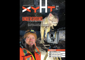
xyHt magazine’s April 2024 issue focuses on land surveying by looking at changes above ground and an interesting survey below ground. As always, if you don’t have a subscription to our print edition, or if someone else in the office has snaffled your copy, don’t fret, here is the digital edition. Click here or on the...

xyHt Digital Magazine: Dec 23/Jan 24
xyHt magazine’s December/January issue is our annual look at young geospatial professionals who are becoming movers and shakers in the industry. This month the magazine presents 24 young pros to watch for 2024. As always, if you don’t have a subscription to our print edition, or if someone else in the office has snaffled your...

Recording Earth’s Changes
Looking Forward What could you do if the entire world was remapped every 12 days? How would that impact your sector of the geospatial world? I pose the question because it is in the process of being answered, though not necessarily from the geospatial professionals’ point of view. So, it is important that we all...

xyHt Weekly News Recap: 11/11/22
Former NGA Director Robert Sharp Joins UMSL Geospatial Collaborative Registration Open for 2023 Common Ground Alliance Expo Sneak Peak at GeoWeek AI Improves the Location of Objects Inside Industrial Environments RIEGL announces NEW VZ-600i
xyHt Weekly News Recap: 11/04/22
RIEGL announces NEW VZ-600i Hexagon to Update Aerial Data of Eight U.S. States at Six-Inch Resolution in 2023 Bracell Wins EU Esri 2022 Award with Geoprocessing Project SuperMap Showcased GIS Technologies and Solutions at INTERGEO 2022 Topcon Invests in the Future of Construction with Donation to TU Dublin VOTIX Software Allows AviSight to Achieve BVLOS...
xyHt Weekly News Recap: 10/28/22
INTERGEO Celebrates a Successful Comeback Fathom launches new Global Flood Map Innoviz and Kudan Team Up for Lidar-Based Geospatial Mapping Solution Across Industries Cartegraph and Center for Digital Government Share Results of Infrastructure Funding and Technology Survey Leica AP20 AutoPole wins Wichmann Innovations Award at INTERGEO 2022 New Lidar Solution Delivers Survey-Grade Data from UAV...