Category Archives: Cartography

The State of MAPPS
Rapidly moving forward in a pandemic and beyond It has been an exciting year in the MAPPS community! While much of the nation was somewhat idle, our MAPPS members were actively supporting our nation’s needs from our offices, at job sites, and remotely at our homes, fulfilling needs emanating from federal, state, and local government...
Reasons Not to Apportion Subdivision Lots
Apportioning excess or deficiency in platted lots seems like a quick and painless solution to a problem subdivision retracement when original corner marks are not immediately apparent.
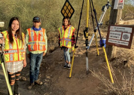
Generation S(urveyor)?
A surveyor’s children are introduced to the ancient craft with real, hands-on experience
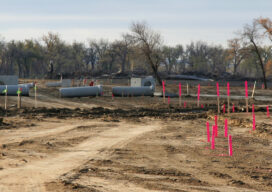
Remote Sensing – It’s About the Safety
If you follow trends in industry that serve our profession, it is impossible to not see articles and advertisements about the use of remote sensing technology. Unmanned Aerial Systems (UAS/drones) tend to be the leaders of the pack for many reasons. However, there are several others, from stationary and mobile terrestrial lidar scanners and cameras,...

NSPS, Geospatial Firms and Others Support IIJA
In a letter to U.S. senators, the National Society of Professional Surveyors, geospatial firms, AEC firms, and transportation entities urged all senators to support the Infrastructure Investment and Jobs Act (IIJA), saying it will “provide meaningful economic and quality of life enhancements to communities across the country.” In all, 76 firms urged passage of the...

Karen Schuckman is the ASPRS’ Next Executive Director
The ASPRS Board of Directors has announced the appointment of Karen Schuckman as the next executive director of ASPRS. “After a thorough and extensive search process, the ASPRS board of directors has named Karen Schuckman as its next executive director. Karen, in her previous positions in ASPRS, has demonstrated an incredible commitment to seeing the...