September 2018 Archives
Cooperative Effort Takes Off
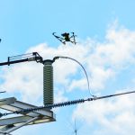
Tapping into UAS technology creates possibilities for a northern Arizona utility. Sometimes, the most effective, revelatory, progressive solutions to a problem can be found in the unlikeliest of places. Case in point: three and a half hours north of Phoenix in the city of Lakeside, Arizona, an electric cooperative that serves more than 33,000 member […]
Continuing Ed Outside Your Comfort Zone

Learn new skills by taking continuing education seriously. Since its inception in the geomatics arena in the 1990s, the requirement for continuing education (also called continuing competency) has had the aura of a penalty rather than an opportunity. Obtaining legislative approval in many states for the continuing education requirement was difficult. Getting courses approved for […]
More Than Just Autopilot
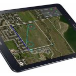
Your UAS flight management system affects accuracy in photogrammetry, so get to know what you need. Unmanned aircraft systems (UAS) are arguably the most disruptive technology introduced to the geospatial profession since GPS. Advances in UAS capabilities and in photogrammetry software have significantly reduced the barrier to generating digital surface models (DSM) and orthomosaics from […]
Time & Progress
Editor’s note: As an example of how far QGIS has evolved and the depth of the many features and plugins, Anita Graser, key member of the QGIS team and author of popular QGIS guide books, offers the following details. Graser was also one of xyHt’s 2015 inaugural 40 geospatial professionals under 40. More and […]