Tag Archives: ASPRS

xyHt Weekly News Links: 7/28/17
INTERGEO – bridge to a digital future New Leica Captivate Pipeline application streamlines tracking and reporting Trimble introduces new Android app – Trimble Penmap – for field surveying and data collection ESA communication team hands off responsibility to GSA LizardTech optimizes Portfolio 2017 for geospatial data Icaros and TeAx Announce an Integrated Drone Mapping Solution...
UAS: From FUD to FOMO
By Jeff Salmon Welcome to our semi-annual UAS-focused issue. Looking back over the last six years of UAS development, I am struck by how far the technology has progressed. Right before our eyes a new industry has developed, one that promises to bring far-reaching changes to our profession and indeed to the whole world. And...

ILMF and ASPRS Annual Conference to Take Place Together in Denver in 2018
ILMF Annual Conference plus ASPRS Annual Conference equals… Diversified Communications, organizer of International LiDAR Mapping Forum (ILMF) and the American Society for Photogrammetry & Remote Sensing (ASPRS) announced that their annual geospatial events will take place together in Denver in 2018. Lisa Murray, Director of ILMF, made the announcement with ASPRS President Charles Toth during...
xyHt News Links: 9/23/16
SimActive Brings Picture-in-Picture 3D Viewing with Version 6.5 ASPRS Executive Director Stepping Down NovAtel announces VEXXIS family of GNSS antennas 3D Target to Launch Payload Lidar at Intergeo Geodetics introduces mobile mapping system with lidar, GPS
xyHt News Links: 4/8/16
Teledyne Optech Press Release: Teledyne Optech to unveil autonomous mapping system at SPAR 3D NCTech unveils new 360 degree imaging developments for iSTAR camera Teledyne Optech to announce new airborne system at ASPRS Imaging & Geospatial Technology Forum (IGTF) Trimble GNSS Options For CEESCOPE Teledyne to Acquire CARIS New Veripos GNSS Visualisation Software Fast Growing AirMap...
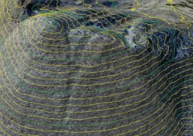
Comparing Maps a New Way
Above: The new standards are independent of map scale or contour interval and provide a way to deal with lidar data. ASPRS releases new positional accuracy standards. The positional accuracy of geospatial technologies has improved dramatically in the past few decades, and digital maps have replaced paper maps, making old ways of comparing maps obsolete. Satellite...