Tag Archives: Blue Marble

Global Mapper Review
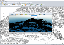
Although I’ve been using GIS for more years than I can remember, until xyHt took me out to InterGeo I had never heard of Global Mapper. I thought I’d used every GIS there was; I’ve even used some that only a select few have ever heard of (StruMap anyone?). The market is saturated with GIS, and...

xyHt Weekly News Links: 9/8/17
This page includes a weekly roundup of industry news links for surveying, UAS, location technology, web mapping, hydrographics, engineering, construction, and more. NPL 322+ New Reflectorless and Prism-only Total Station SimActive Releases Correlator3D™ Version 7.0 Hurricane Harvey Early Predictive Analysis with Wind and Storm Surge Data Blue Marble Provides Free Copies of Global Mapper to...
xyHt Weekly News Recap: 5/19/17
Satlab Geosolutions introduces Ultra-Compact Multiconstellation GNSS UAV/RTK Receiver including Dual Antenna Heading capability senseFly Corridor solution boosts efficiency of linear mapping projects Icaros Releases Version 5.0 of OneButton™ Drone Image Processing Software Congress increases funding for UAS research, airspace integration Blue Marble Releases Mobile Friendly Version of the GeoCalc Geodetic Registry Swift, Carnegie release Duro for...
Weekly xyHt News Links: 4/7/17
Qinertia, a post-processing software to complete our offer for the surveying industry TCarta Marine to Introduce Gulf of Mexico Streaming Basemap Service and 2-Meter Bathymetric Data at Esri Petroleum Conference ClearEdge3D Releases VerityTM Construction Verification Software Tallysman introduces dual-band plus L-band GNSS antenna A look at NGS’ GPS on benchmarks program in Alaska Blue Marble Offers Free...