Tag Archives: DAT/EM

Three Trends at SPAR International 2017
I’ve attended SPAR every year since its inception in 2004, always while working for a vendor for 3D laser scanning products. This year, sporting my new xyHt shirt, I viewed the event from a different perspective. Let me preface this “review” by noting that I did not do a complete walk-around of each vendor’s booth;...

xyHt News Links: 9/30/16
Trimble Launches New Portfolio of Wireless IoT Sensors for Water Monitoring DAT/EM Releases Version 7.3 Orbit GT to launch Mobile Mapping v17 at Intergeo, Hamburg Geodetics introduces mobile mapping system with lidar, GPS senseFly and Maptek sign agreement around data collection and analysis solution DroneDeploy Speeds Up Drone Mapping for Remote Users With Limited Internet...
xyHt News Links: 1/8/16
Phase One Industrial Announces 100 Megapixel Medium Format Metric Cameras for Aerial Data Acquisition CES 2016 – Inuitive and gestigon bring gesture recognition to embedded virtual reality platforms DAT/EM Systems International Releases 7.2 Septentrio’s Pinpoint-GIS is available on the ArcGIS Marketplace Leading LiDAR Expert, Tim Blak, Joins Atlantic Berntsen International ranked among top 300 B2B E-Commerce...
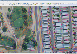
From Traditional Photogrammetry to UAS
Photogrammetry has changed substantially in the past three decades. When Jeff Yates began in the business 32 years ago, he used a projection system known as a Kelsh two-bucket plotter. “That was four generations ago of photogrammetric systems hardware,” he recalls. “From there, we went to the analog stereo plotter. That was the second big...