Tag Archives: datums
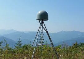
The New Datum and Real-Time GNSS Networks
We asked U.S. RTN what their plans are for the upcoming changes to the National Spatial Reference System. When it comes to geodetic reference frameworks, “shift happens.” Surveyors (and others) have been through this before, like changes from NAD27 to NAD83, NGVD29 to NAVD88, from NAD83(CORS96) to NAD83(NSRS2007), and to the current NAD83(2011). Remember the...
CGVD2013, Part 2
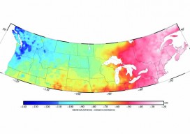
Above picture: This color contour map shows the difference between CGVD2013 and NAVD 88, especially of interest to those who work on projects along the U.S./Canada border. In part 1 of this series in xyHt’s October issue, Canada’s new vertical datum is introduced—CGVD2013— with an overview of past Canadian datums, directions during the current transition...

Canada’s New Vertical Datum: CGVD2013
Geodesy Editor’s Note: The study of Earth’s gravity field is one of the most important aspects of physical geodesy. While seldom mentioned in land surveying text books or discussed at local surveying, mapping, or GIS conferences, it is nonetheless one of the most important issues that geospatial experts deal with on a daily basis. Changing...