Tag Archives: digital globe

GEO Business 2018: “Geocoolness” in the London Heat
Trends in geomatics tech and spatial IT at the UK’s premier annual geo conference and exhibition Editor’s Note: GEO Business is an annual conference held annually in London. xyHt’s Europe editor, Nick Duggan has been attending each year, chronicling trends in the geo industry. The event is growing into one of the premier geo events...
Joshua Sisskind
Software Developer at DigitalGlobe A skilled geospatial developer, Joshua Sisskind is also dedicated to growing the geospatial professions. He works on the open-source software toolkit Hootenanny, a joint effort between National Geospatial-Intelligence Agency and DigitalGlobe, that provides a scalable processing engine and interactive editing interface to enable rapid conflation of map features generated from satellite...
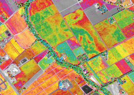
Satellite Imagery for Precision Agriculture
Precision agriculture consists primarily of using geospatial technologies to map spatial variations in crop and soil conditions and to match inputs—such as water, seed, and fertilizer—to those variations by applying them at variable rates. The link between the spatial variations and the variable rates are zone maps and prescription maps. The former show the difference...