Tag Archives: FOSS

Supporting Free and Open-Source Software
Free and open-source software (FOSS) is sweeping across the IT industry, everywhere from office programs (LibreOffice) to GIS software (QGIS, R, Python). It is also being used extensively by large companies such as Microsoft, IBM, Amazon, and Netflix for their internal services as well as being used as building blocks to offer services to clients. ...

The Program R
What is it, and what can it do for AEC? R is a free, open source program that is becoming increasingly popular in the geospatial industry. R used to be the preserve of statisticians, but its open and flexible nature has allowed it to grow to cover a wide range of disciplines and user bases....
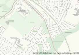
OS Zoomstack – the Gift that Keeps On Giving
On July 17 2018, Ordnance Survey (OS), the United Kingdom’s national mapping agency, released a trial of a product called “OS Zoomstack.” At the time many overlooked it, as Ordnance Survey makes lots of their data over 1:5000 available for free. I have to admit I was one of them. In August of last year,...
QGIS Details
How features are developed, plus details on releases, support, and plugins. Editor’s note: Tim Sutton has been a figurehead for free and open source software (FOSS), is past chair of the QGIS steering committee and is also co-owner of Kartoza. Here he kindly writes about how QGIS works on a project level from his vast...
QGIS: What Is It and How Does It Work?
Editor’s Note: Nowadays everything costs, whether you are a solo practitioner, in a small business, or part of a large firm seeking to expand. You buy a new laptop, you need an operating system, then office software, then a broadband subscription; the cost keeps escalating. Are you bound to this legacy progression of costs? Not...