Tag Archives: Ireland

xyHt Weekly News Recap: 04/28/2023
Topcon Launches Easy-to-Use Building Construction Software Digital Construction Week Reveals Main Stage Lineup OGC Requests Public Comment on a Standardized Deformation Model and a Geodetic Data Grid Exchange Format AUV Helps Locate World War II Ship 80 years After Tragic Sinking Bluesky and Ecopia Partner to Create First 3D Map of Ireland Get Special Hotel...
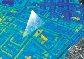
Protecting Urban History
Maximizing the data collected from airborne lidar helps protect historic structures in older cities In Part I last month, we outlined the research performed in Dublin, Ireland, and Brooklyn, N.Y., using hyperspectral scanning to help old cities protect historically significant buildings during new construction projects. In Part II, NYU professor, Dr. Debra Laefer, explains how...
xyHt Weekly News Recap: 2/12/2021
senseFly Expands Line of Fixed-Wing Drones Trimble Introduces Next Generation of 3D Paving Control Bluesky Creates First 3D Map of Northern Ireland Coastline NSPS 2021 Student Competition WiBotic Launches Software Package for Robot Fleets Drones Made in America Photogrammetry Company Matterport to Go Public in $3 Billion Deal